Solved

SID to GeoTIFF conversion error


fikusas
Contributor
Forum|alt.badge.img+5

I'm getting the error message then converting SID file to GeoTIFF raster:

1MRSID reader: MrSIDRasterBand::IRasterIO(): Failed to load image. mg2d internal error [8021]
2MRSID reader: Failed to retrieve data from the source dataset

Any ideas how to solve this?

Best answer by sigtill

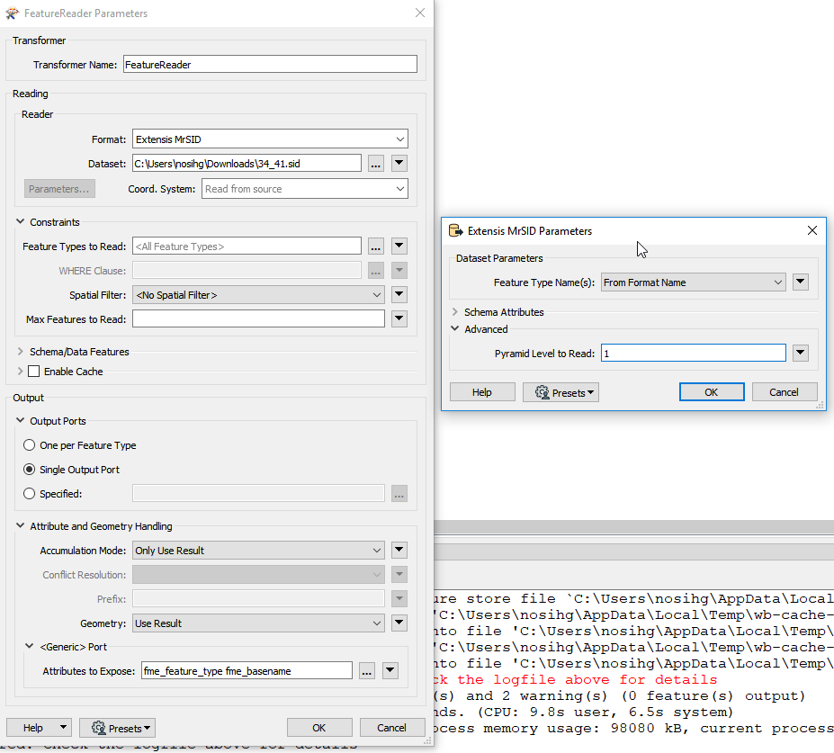
You can also read Pyramid layer 1 - instead of default 0 to get this in FME: Then it has the resolution original resolution / 2 = 1m.


View original
Did this help you find an answer to your question?
This post is closed to further activity.
It may be an old question, an answered question, an implemented idea, or a notification-only post.
Please check post dates before relying on any information in a question or answer.
For follow-up or related questions, please post a new question or idea.
If there is a genuine update to be made, please contact us and request that the post is reopened.

9 replies

itay
Supporter
Forum|alt.badge.img+18
  • Supporter
  • October 17, 2019

Hi @fikusas,

Can it be that the lack of coordinate system elements (datum and ellipsoid) are causing the issue?


fikusas
Contributor
Forum|alt.badge.img+5
  • Author
  • Contributor
  • October 17, 2019
itay wrote:

Hi @fikusas,

Can it be that the lack of coordinate system elements (datum and ellipsoid) are causing the issue?

I think it can't be a problem, 'cause all other SID files aren't with defined coordsys either, but don't give this kind of error.


itay
Supporter
Forum|alt.badge.img+18
  • Supporter
  • October 17, 2019
fikusas wrote:

I think it can't be a problem, 'cause all other SID files aren't with defined coordsys either, but don't give this kind of error.

From what I could find online it seems that some lines in the raster are corrupted. Not a big help but opening with GDAL provides the same error and since FME uses GDAL this is to be expected, so I think the issue is the input raster.


fikusas
Contributor
Forum|alt.badge.img+5
  • Author
  • Contributor
  • October 17, 2019
itay wrote:

From what I could find online it seems that some lines in the raster are corrupted. Not a big help but opening with GDAL provides the same error and since FME uses GDAL this is to be expected, so I think the issue is the input raster.

Maybe the SID file is damaged, thus unreadable...


sigtill
Supporter
Forum|alt.badge.img+25
  • Supporter
  • October 17, 2019

I used Geoviewer from Lizardtech to open the file - free - https://www.extensis.com/support/geoviewer-9

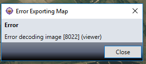
When exporting it seems to give an error

So there is definitely something wrong with a part of the image although it can be viewed partially within the viewer.

I think you have to contact Lizardtech - they might have a MrSIDFix.exe or similar (seem to remember this from way back)


itay
Supporter
Forum|alt.badge.img+18
  • Supporter
  • October 17, 2019
fikusas wrote:

Maybe the SID file is damaged, thus unreadable...

yes that is what I think and @sigtill too..


sigtill
Supporter
Forum|alt.badge.img+25
  • Supporter
  • October 17, 2019

Exporting 1m resolution instead of 0.5m resolution works OK. So there is something wrong with the innermost layer. At least you got some of the data :)

Available 1 week, tif can be downloaded here : https://fil.email/ObiRCCUX


sigtill
Supporter
Forum|alt.badge.img+25
  • Supporter
  • Best Answer
  • October 17, 2019

You can also read Pyramid layer 1 - instead of default 0 to get this in FME: Then it has the resolution original resolution / 2 = 1m.


fikusas
Contributor
Forum|alt.badge.img+5
  • Author
  • Contributor
  • October 17, 2019
sigtill wrote:

You can also read Pyramid layer 1 - instead of default 0 to get this in FME: Then it has the resolution original resolution / 2 = 1m.


Thanks @sigtill !


Cookie policy

We use cookies to enhance and personalize your experience. If you accept you agree to our full cookie policy. Learn more about our cookies.

 
Cookie settings