Solved

get a given point distance

  • March 5, 2020
  • 6 replies
  • 23 views

Forum|alt.badge.img

Hello,

I am interested in how to get a given point distnce with FME.

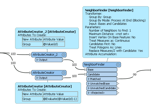
I have points arranged by counter (pontID is ascending) and I want to get the next point's distance. I tried NeighborFinder, but the problem is that sometimes an other point is closer,so it gives a wrong distance.

Thanks!

Best answer by ebygomm

Another way, if the points are in order

  • Coordinate extractor to get coordinates if they don't already exists as attributes
  • Attributecreator with adjacent feature mapping turned on look at one subsequent feature
  • Arithmetic expression to calculate distance using the coordinates of the existing feature, and the coordinates of the adjacent feature
This post is closed to further activity.
It may be an old question, an answered question, an implemented idea, or a notification-only post.
Please check post dates before relying on any information in a question or answer.
For follow-up or related questions, please post a new question or idea.
If there is a genuine update to be made, please contact us and request that the post is reopened.

6 replies

david_r
Celebrity
  • 8392 replies
  • March 5, 2020

Lots of different ways, but one way could be

  1. Sorter on point ID, in ascending, numerical order
  2. LineBuilder to get a line from all the points
  3. Chopper, mode = By Vertex, max vertices = 2 to split into individual line segments
  4. LengthCalculator to get segment lengths

ebygomm
Influencer
Forum|alt.badge.img+44
  • Influencer
  • 3427 replies
  • Best Answer
  • March 5, 2020

Another way, if the points are in order

  • Coordinate extractor to get coordinates if they don't already exists as attributes
  • Attributecreator with adjacent feature mapping turned on look at one subsequent feature
  • Arithmetic expression to calculate distance using the coordinates of the existing feature, and the coordinates of the adjacent feature

ebygomm
Influencer
Forum|alt.badge.img+44
  • Influencer
  • 3427 replies
  • March 5, 2020

A neighbourfinder with a group by then?


Forum|alt.badge.img
  • Author
  • 14 replies
  • March 6, 2020

Lots of different ways, but one way could be

  1. Sorter on point ID, in ascending, numerical order
  2. LineBuilder to get a line from all the points
  3. Chopper, mode = By Vertex, max vertices = 2 to split into individual line segments
  4. LengthCalculator to get segment lengths

i tried this way, but I got in trouble to match the points with the line attributes, cause the line builder gets only the first point's datas...


david_r
Celebrity
  • 8392 replies
  • March 6, 2020

i tried this way, but I got in trouble to match the points with the line attributes, cause the line builder gets only the first point's datas...

Can you post a small sample dataset here? Or at least post some screenshots that details the issue?


bwn
Evangelist
Forum|alt.badge.img+26
  • Evangelist
  • 562 replies
  • March 6, 2020

Like so. Use LineBuilder to also act kind of like a Chopper by pairing the Points first by making a copy of the Points with ID incremented by +1, and then creating Line segments. The LengthCalculator will the measure the distance between the line vertices.

*EDIT* And just realised how similar this solution is to the concepts from @david_r and @ebygomm! Without meaning to, I ended up sketching a hybrid of the 2 solutions. In theory @ebygomm 's solution will be a bit more efficient, although I'm not sure whether NeighborFinder's distance is a Geographic or Cartesian calculation? I went to building Lines instead to make sure the right length for the coordinate system could be extracted. I think the Help implies it is a Cartesian distance only whereas I think the solution you wanted was a Geographic distance that accounted for surface curvature?