Solved

Read GeoPDF as a single PDF and not split into rows.


Forum|alt.badge.img

Hello all,

I am reading a scanned PDF image of a county and I would like it to read as a single file. It appears to be reading it as 7 different files, which will output into 7 different TIFFs.

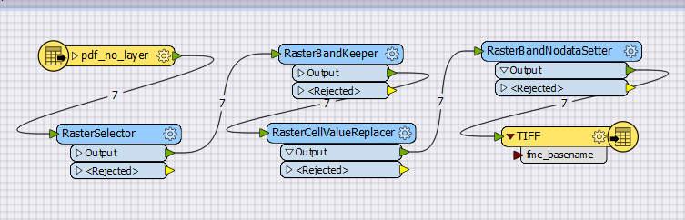
Does anyone know how to fix this problem and make it read as a single PDF image?

Best answer by jakemolnar

Have you tried the non-spatial mode "Read Rasterized Pages"?

rasterized-pages-option.png


You can render the entire page as a single raster with this option, at the size of your choice. I recommend the "Scale" mode.

edit: Oh also, I just thought I'd add: the reason you're seeing 7 different "files" is probably because your PDF embeds 7 different images. In spatial modes, every object in the PDF file is emitted separately. In non-spatial modes, there is generally one feature per page instead.

View original
Did this help you find an answer to your question?

4 replies

jakemolnar
Forum|alt.badge.img
  • Best Answer
  • March 22, 2018

Have you tried the non-spatial mode "Read Rasterized Pages"?

rasterized-pages-option.png


You can render the entire page as a single raster with this option, at the size of your choice. I recommend the "Scale" mode.

edit: Oh also, I just thought I'd add: the reason you're seeing 7 different "files" is probably because your PDF embeds 7 different images. In spatial modes, every object in the PDF file is emitted separately. In non-spatial modes, there is generally one feature per page instead.


Forum|alt.badge.img
  • Author
  • March 22, 2018
jakemolnar wrote:

Have you tried the non-spatial mode "Read Rasterized Pages"?

rasterized-pages-option.png


You can render the entire page as a single raster with this option, at the size of your choice. I recommend the "Scale" mode.

edit: Oh also, I just thought I'd add: the reason you're seeing 7 different "files" is probably because your PDF embeds 7 different images. In spatial modes, every object in the PDF file is emitted separately. In non-spatial modes, there is generally one feature per page instead.

Awesome! Thank you very much, this worked perfectly!


Next time ill try reading the documentation a little better.


jakemolnar
Forum|alt.badge.img
zacharya wrote:
Awesome! Thank you very much, this worked perfectly!


Next time ill try reading the documentation a little better.


I'm glad it worked out for you!


PS. In case it isn't clear in the documentation, the scale (pixels per point) is kind of like a "zoom" parameter. Alternatively, if you know exactly the dimensions of the raster you would like to create, then you can use the "custom" raster size mode.


billmcbride
Contributor
Forum|alt.badge.img+4
  • Contributor
  • September 1, 2023

new user here: would someone suggest the range and settings of the RasterCellValueReplacer and the RasterAndNoDataSetter that would yield a GeoTiff that will satisfy the input conditions for the CADRG converter. I read the docs, but don't understand the use of these two transformers yet.


Cookie policy

We use cookies to enhance and personalize your experience. If you accept you agree to our full cookie policy. Learn more about our cookies.

 
Cookie settings