
I have a raster in which I need to change the vertical datum. I tried using the CSMapReprojector but it didn't work. It looks like FME just always sees the Raster at 2D when I view it in the Data Inspector. Is this a bug?

Solved
How can I change the Vertical Datum (Vertically Reproject) in a Raster DEM


 +22
+22- Safer
Best answer by fmelizard
This is not a bug. FME will always interpret a raster as 2D. The height information is stored in the pixels of the raster image. To shift the vertical datum it's probably easiest to first convert it to a Point Cloud, then perform the vertical shift and then change it back into a Raster.
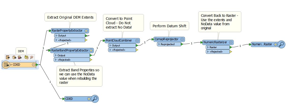
You can try it your self here: reprojectrasterheights.fmwt
(Data sourced from the City of Vancouver)
This post is closed to further activity.
It may be an old question, an answered question, an implemented idea, or a notification-only post.
Please check post dates before relying on any information in a question or answer.
For follow-up or related questions, please post a new question or idea.
If there is a genuine update to be made, please contact us and request that the post is reopened.
It may be an old question, an answered question, an implemented idea, or a notification-only post.
Please check post dates before relying on any information in a question or answer.
For follow-up or related questions, please post a new question or idea.
If there is a genuine update to be made, please contact us and request that the post is reopened.
Login to the community
No account yet? Create an account
An FME Account is required to contribute
LoginEnter your E-mail address. We'll send you an e-mail with instructions to reset your password.