Question

geotif writer always uses jpeg compression


koenvdw
Contributor
Forum|alt.badge.img+6

Hi guy’s


A workbench that worked before gives me some crazy errors that’s driving me nuts.

I used the workbench before and it worked normally. 


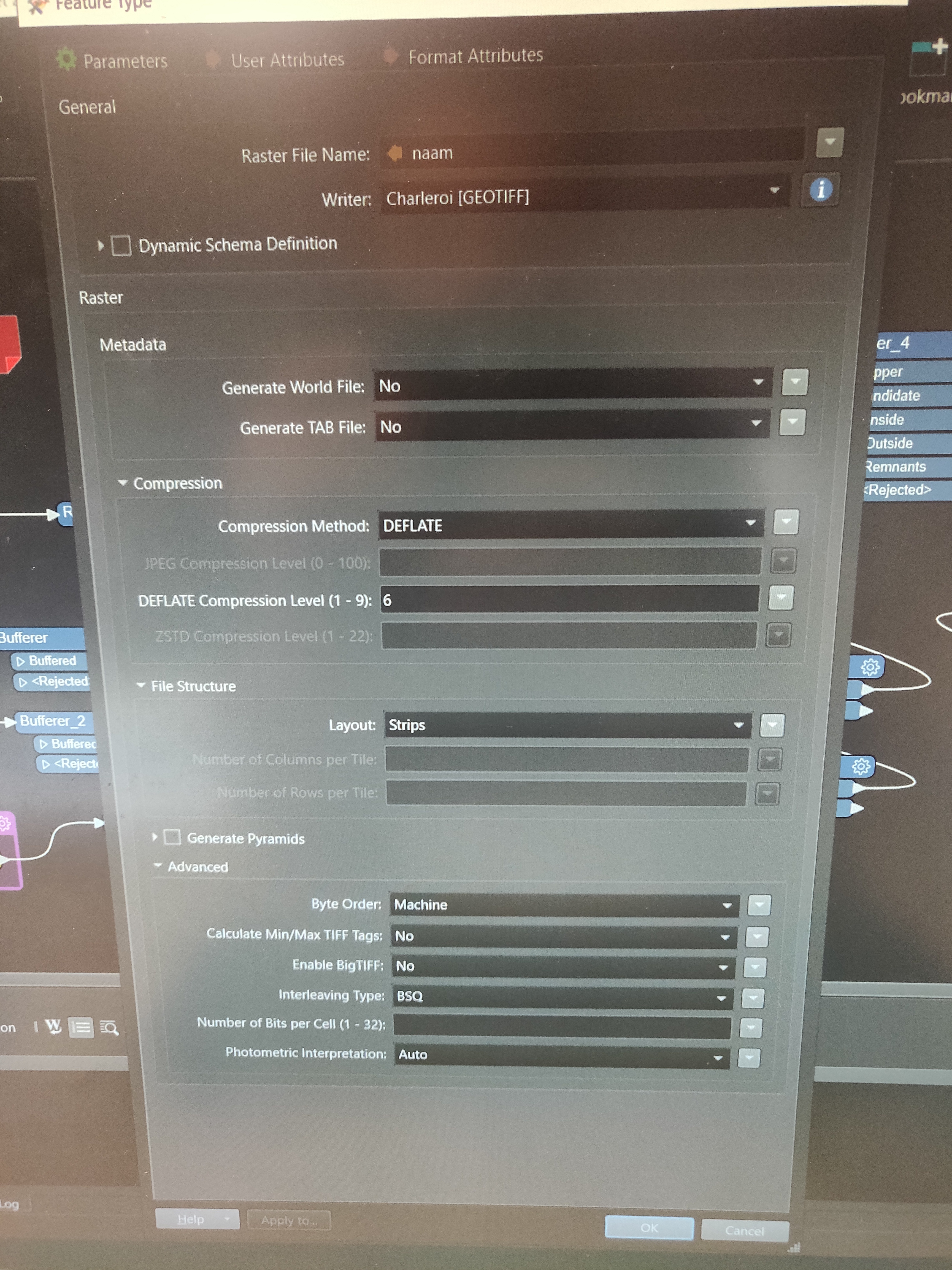
It has to write some geotif tiles with deflate compression. No matter what I do, I always get errors about me using jpeg compression. I tried everything. Clearing cache, deleting cache manually, restarting pc, copying everything in new FME file, updating all the transformers, making a new wb, try running it on another pc with more recent version of FME...


I had a similar question in the past and than the solution was to use a bulkattributeremover with ‘geotif_’. 

This doesn’t work either. 

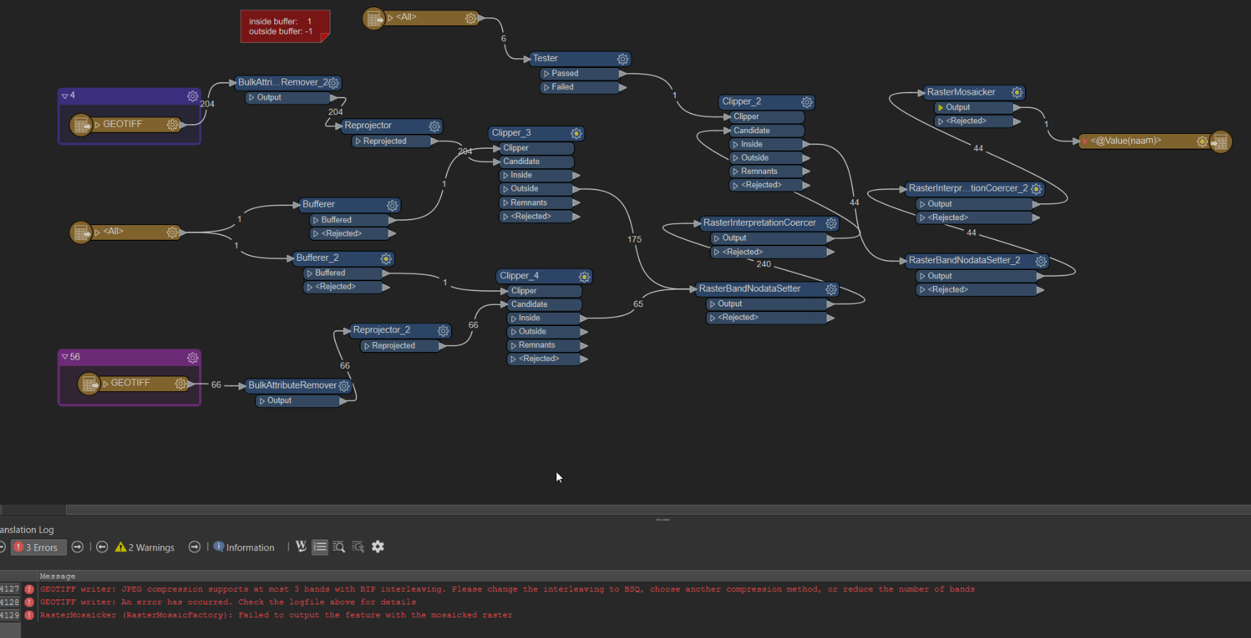
This is the wb, it’s just shapefiles and geotifs as import:


Any one with ideas?

5 replies

redgeographics
Celebrity
Forum|alt.badge.img+48

Can you post a screenshot of how the GeoTiff writer is set up?


koenvdw
Contributor
Forum|alt.badge.img+6
  • Author
  • Contributor
  • April 5, 2024

Like this:


redgeographics
Celebrity
Forum|alt.badge.img+48

Okay, that’s clearly set to DEFLATE, which makes me wonder why you’re seeing errors about JPG compression. Maybe you should send this in to Safe’s support?


virtualcitymatt
Celebrity
Forum|alt.badge.img+34

I recently had an oddly similar issue with an old workspace which I started running in FME 2023 - I’m not sure if you upgraded from 2021 or earlyer since the last time you used it? For me the issue was related somehow to band selection. I was trying to output a JPEG but fot some reason the RasterMosaicker was only working on the Alpha band and i ended up with just rubbish. I had to move a few things around until it was working properly. I think I had used a RasterSelector followed by a RasterBandRemover. Indeed there is a comment in the RasterSelector doc about a change in FME 2021.1: https://docs.safe.com/fme/html/FME-Form-Documentation/FME-Transformers/Transformers/rasterselector.htm perhpas somehow this change has broken your workspace. could just be a coincidence though.

My gut still says that somehow there are still some attributes coming from the input even though you are removing these. 

I guess I would want to know if the input Geotiffs did actually use jpeg compression, it could be for some reason the BulkAttributeRemovers aren’t working - or at least somehow are still getting used. 


koenvdw
Contributor
Forum|alt.badge.img+6
  • Author
  • Contributor
  • April 5, 2024

I’m working in FME 2022.

I was lucky that the tiles that I wanted to make were not on the municipality border.

So they were full rectangle tiles and I didn’t needed the alpha band. So I could use the jpeg compression to make the tiles by selecting the first three bands and then only keeping these three.


So stupid, I got a whole data set and 6 tiles are different because of this… Not good for my OCD.

I just don’t like it when things aren’t logical anymore. 


I’ll update to a newer version, but as I said I ran it on FME 2023.

Thanks for the tips guys. 

I’ll try to do a follow up if I get it working again.


Cookie policy

We use cookies to enhance and personalize your experience. If you accept you agree to our full cookie policy. Learn more about our cookies.

 
Cookie settings