The .ecw file created through FME, QGIS cannot identify its CRS correctly. I tried with both ecw v2 and v3. This can be fixed through ECW header edit. It might be a bug when trying to write GDA2020 datum to ecw file.
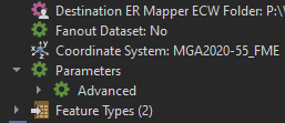
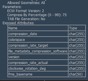
The .ecw file created through FME, QGIS cannot identify its CRS correctly. I tried with both ecw v2 and v3. This can be fixed through ECW header edit. It might be a bug when trying to write GDA2020 datum to ecw file.


Hi @brandonguo,
In its original form, the ECW format allows only a limited number of coordinate systems and datums, using their own codes for these. This has been extended by many producers (including FME), by using the appropriate EPSG codes for a name.
For the 2020 version, FME also uses the EPSG code for the datums not natively supported by ECW, instead of the previously used value of RAW. We have seen cases where this seems to confuse QGIS, which seems to use this EPSG code for the coordinate system instead of the datum.
Would you be able to provide more information on the issue you are seeing with the GDA2020 datum? It would help us in crafting a solution to the problem faced by QGIS users.
Thanks @daveatsafe
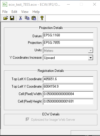
A screenshot of ecw created by FME open in the ECW header editor.
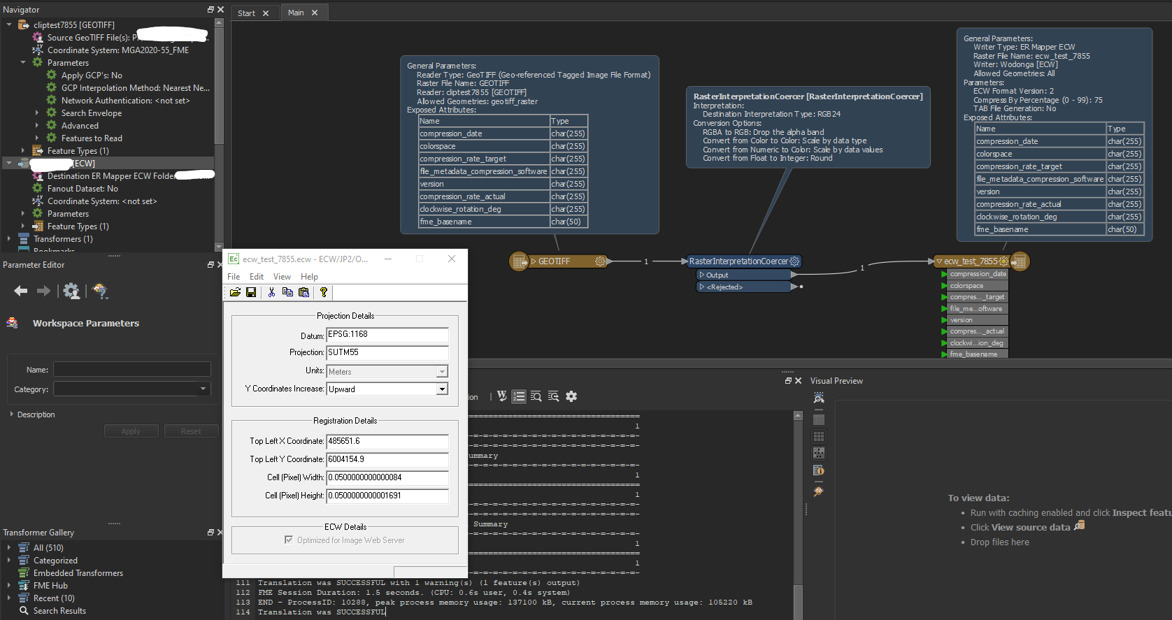
After change the projection information as below, the file can be identified by QGIS:
Thanks @daveatsafe
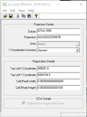
A screenshot of ecw created by FME open in the ECW header editor.

After change the projection information as below, the file can be identified by QGIS:

Hi @brandonguo,
I would recommend setting the Datum to RAW rather than EPSG:7855. This is the EPSG code for the GDA2020/Zone5 projection, rather than the datum.
Hi @brandonguo,
I would recommend setting the Datum to RAW rather than EPSG:7855. This is the EPSG code for the GDA2020/Zone5 projection, rather than the datum.
Thanks for pointing out this. That's better.
Thanks @daveatsafe
A screenshot of ecw created by FME open in the ECW header editor.

After change the projection information as below, the file can be identified by QGIS:

@brandonguo with the issue you encounter above was the solution in FME by changing the datum to "RAW" as @daveatsafe mentioned? (If so can you expand on how that is done). Or was the fix in manually editing the ECW header to appear as you have it above? In experiencing the same issue as in your initial post and screenshot for the same GDA2020 scenario.
Thanks @daveatsafe
A screenshot of ecw created by FME open in the ECW header editor.

After change the projection information as below, the file can be identified by QGIS:

It was fixed manually in ECW header editor. @andrewjeffrey
Hi @brandonguo , @andrewjeffrey , and @daveatsafe thanks very much for posts and discussion here. I had encountered this also, and only just came across your posts and solutions. I was just wondering @daveatsafe , is there anything that is preventing FME being able to correctly write the EPSG code to the ECW header? It seems a bit clunky to need to edit the ECW file header in an external editor once FME has successfully written the ECW file.
Thanks very much
Hi @daveatsafe , sorry just saw your request above for more info. Not sure if this helps, but please see below the report that that the GDALINFO utility provides on this ECW, which I wrote using FME to EPSG 7855. The relevant error seems to be 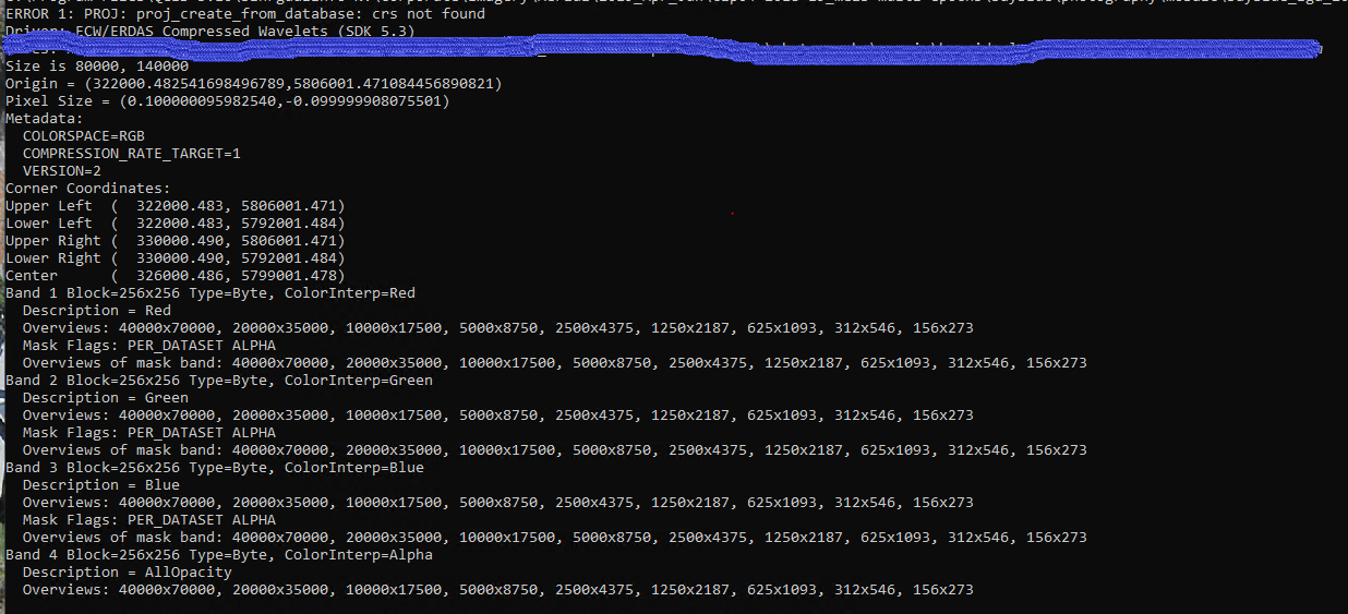 ERROR 1: proj etc on the first line.
Happy to provide any other data that will help
Thanks
Jamie
Hi @brandonguo , @andrewjeffrey , and @daveatsafe thanks very much for posts and discussion here. I had encountered this also, and only just came across your posts and solutions. I was just wondering @daveatsafe , is there anything that is preventing FME being able to correctly write the EPSG code to the ECW header? It seems a bit clunky to need to edit the ECW file header in an external editor once FME has successfully written the ECW file.
Thanks very much
I agree.
Hi @brandonguo,
In its original form, the ECW format allows only a limited number of coordinate systems and datums, using their own codes for these. This has been extended by many producers (including FME), by using the appropriate EPSG codes for a name.
For the 2020 version, FME also uses the EPSG code for the datums not natively supported by ECW, instead of the previously used value of RAW. We have seen cases where this seems to confuse QGIS, which seems to use this EPSG code for the coordinate system instead of the datum.
Would you be able to provide more information on the issue you are seeing with the GDA2020 datum? It would help us in crafting a solution to the problem faced by QGIS users.
I have the same problem. ECW tiles and mosaics I've created with FME 2022.0.0.2 (20220518 - Build 22343 - WIN64) result in:
I've tried replacing coordinate system parameter in FME feature reader from 'CSRS.UTM-13N' (read from source) to 'EPSG:2957', with the same result and an additional FME warning message: "NOT changing coordinate system of reader identified by keyword `R_2' from `EPSG:2957' to `CSRS.UTM-13N' -- mapping file setting of `EPSG:2957' overrides coordinate system `CSRS.UTM-13N' read from file"
Several web searches indicate that it may be necessary to use the "ECW header editor" to fix ECW's created by FME. Does"https://download.hexagongeospatial.com/downloads/ecw/geocompressor-2022-update-1-windows" include this "ECW header editor" and is it free?
Where is the list of coordinate systems and datums supported within the ECW format?
Yes, the header editor is free.
I have the same problem. ECW tiles and mosaics I've created with FME 2022.0.0.2 (20220518 - Build 22343 - WIN64) result in:
I've tried replacing coordinate system parameter in FME feature reader from 'CSRS.UTM-13N' (read from source) to 'EPSG:2957', with the same result and an additional FME warning message: "NOT changing coordinate system of reader identified by keyword `R_2' from `EPSG:2957' to `CSRS.UTM-13N' -- mapping file setting of `EPSG:2957' overrides coordinate system `CSRS.UTM-13N' read from file"
Several web searches indicate that it may be necessary to use the "ECW header editor" to fix ECW's created by FME. Does"https://download.hexagongeospatial.com/downloads/ecw/geocompressor-2022-update-1-windows" include this "ECW header editor" and is it free?
Where is the list of coordinate systems and datums supported within the ECW format?
Hi @pascal_cyr,
Please try using the latest FME 2022.1 beta version, which can be downloaded from safe.com/beta. We have updated the coordinate system handling for ECW v3 files to be better compatible with QGIS and ArcGIS.
I have the same problem. ECW tiles and mosaics I've created with FME 2022.0.0.2 (20220518 - Build 22343 - WIN64) result in:
I've tried replacing coordinate system parameter in FME feature reader from 'CSRS.UTM-13N' (read from source) to 'EPSG:2957', with the same result and an additional FME warning message: "NOT changing coordinate system of reader identified by keyword `R_2' from `EPSG:2957' to `CSRS.UTM-13N' -- mapping file setting of `EPSG:2957' overrides coordinate system `CSRS.UTM-13N' read from file"
Several web searches indicate that it may be necessary to use the "ECW header editor" to fix ECW's created by FME. Does"https://download.hexagongeospatial.com/downloads/ecw/geocompressor-2022-update-1-windows" include this "ECW header editor" and is it free?
Where is the list of coordinate systems and datums supported within the ECW format?
Result with FME 2022.1 beta version:
I have the same problem. ECW tiles and mosaics I've created with FME 2022.0.0.2 (20220518 - Build 22343 - WIN64) result in:
I've tried replacing coordinate system parameter in FME feature reader from 'CSRS.UTM-13N' (read from source) to 'EPSG:2957', with the same result and an additional FME warning message: "NOT changing coordinate system of reader identified by keyword `R_2' from `EPSG:2957' to `CSRS.UTM-13N' -- mapping file setting of `EPSG:2957' overrides coordinate system `CSRS.UTM-13N' read from file"
Several web searches indicate that it may be necessary to use the "ECW header editor" to fix ECW's created by FME. Does"https://download.hexagongeospatial.com/downloads/ecw/geocompressor-2022-update-1-windows" include this "ECW header editor" and is it free?
Where is the list of coordinate systems and datums supported within the ECW format?
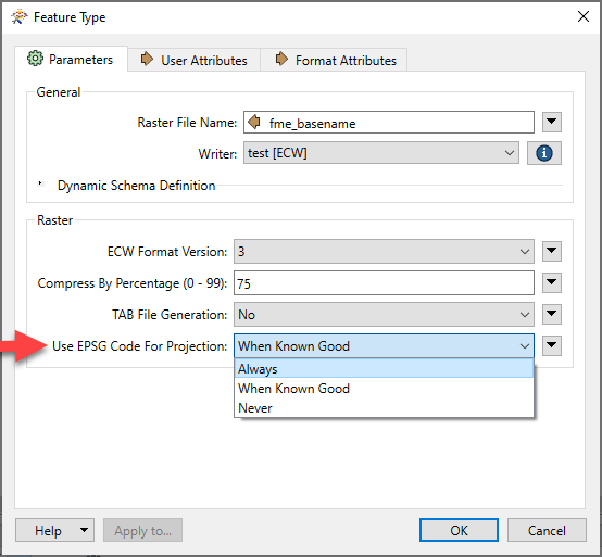
Please try setting the output ECW feature type parameter Use EPSG Code for Projection to Always.
I have the same problem. ECW tiles and mosaics I've created with FME 2022.0.0.2 (20220518 - Build 22343 - WIN64) result in:
I've tried replacing coordinate system parameter in FME feature reader from 'CSRS.UTM-13N' (read from source) to 'EPSG:2957', with the same result and an additional FME warning message: "NOT changing coordinate system of reader identified by keyword `R_2' from `EPSG:2957' to `CSRS.UTM-13N' -- mapping file setting of `EPSG:2957' overrides coordinate system `CSRS.UTM-13N' read from file"
Several web searches indicate that it may be necessary to use the "ECW header editor" to fix ECW's created by FME. Does"https://download.hexagongeospatial.com/downloads/ecw/geocompressor-2022-update-1-windows" include this "ECW header editor" and is it free?
Where is the list of coordinate systems and datums supported within the ECW format?
How? Please provide a documented example and/or the relevant help page(s).
I have the same problem. ECW tiles and mosaics I've created with FME 2022.0.0.2 (20220518 - Build 22343 - WIN64) result in:
I've tried replacing coordinate system parameter in FME feature reader from 'CSRS.UTM-13N' (read from source) to 'EPSG:2957', with the same result and an additional FME warning message: "NOT changing coordinate system of reader identified by keyword `R_2' from `EPSG:2957' to `CSRS.UTM-13N' -- mapping file setting of `EPSG:2957' overrides coordinate system `CSRS.UTM-13N' read from file"
Several web searches indicate that it may be necessary to use the "ECW header editor" to fix ECW's created by FME. Does"https://download.hexagongeospatial.com/downloads/ecw/geocompressor-2022-update-1-windows" include this "ECW header editor" and is it free?
Where is the list of coordinate systems and datums supported within the ECW format?
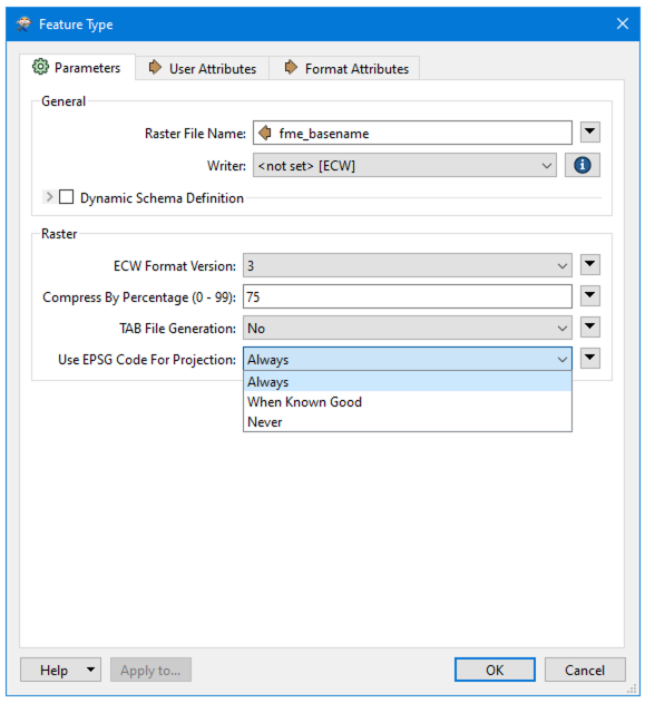
Right-click on the output ECW feature type and choose Properties: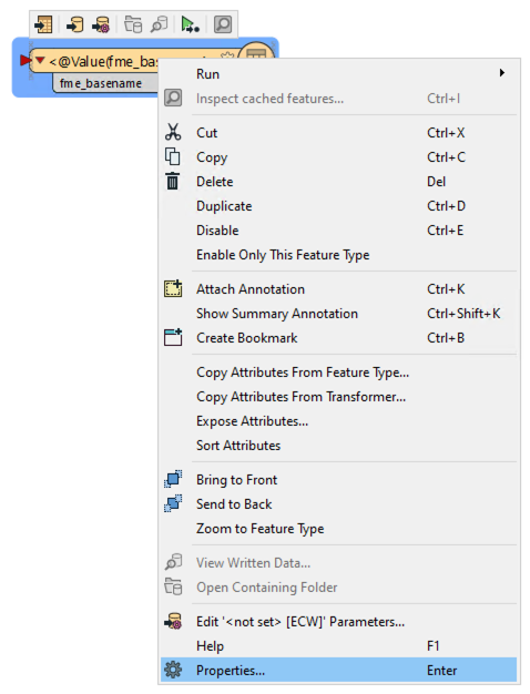 In the dialog that opens, set Use EPSG Code for Projection to Always:
I have the same problem. ECW tiles and mosaics I've created with FME 2022.0.0.2 (20220518 - Build 22343 - WIN64) result in:
I've tried replacing coordinate system parameter in FME feature reader from 'CSRS.UTM-13N' (read from source) to 'EPSG:2957', with the same result and an additional FME warning message: "NOT changing coordinate system of reader identified by keyword `R_2' from `EPSG:2957' to `CSRS.UTM-13N' -- mapping file setting of `EPSG:2957' overrides coordinate system `CSRS.UTM-13N' read from file"
Several web searches indicate that it may be necessary to use the "ECW header editor" to fix ECW's created by FME. Does"https://download.hexagongeospatial.com/downloads/ecw/geocompressor-2022-update-1-windows" include this "ECW header editor" and is it free?
Where is the list of coordinate systems and datums supported within the ECW format?
Upgrading to the FME 2022.1 beta version failed to add that option to the pre-existing ECW writer dialogs. After checking FME terminology, I added a new "ER Mapper ECW" Writer to the existing workspace. Here are the results with the new writer set to ECW v3 and "Always":
I have the same problem. ECW tiles and mosaics I've created with FME 2022.0.0.2 (20220518 - Build 22343 - WIN64) result in:
I've tried replacing coordinate system parameter in FME feature reader from 'CSRS.UTM-13N' (read from source) to 'EPSG:2957', with the same result and an additional FME warning message: "NOT changing coordinate system of reader identified by keyword `R_2' from `EPSG:2957' to `CSRS.UTM-13N' -- mapping file setting of `EPSG:2957' overrides coordinate system `CSRS.UTM-13N' read from file"
Several web searches indicate that it may be necessary to use the "ECW header editor" to fix ECW's created by FME. Does"https://download.hexagongeospatial.com/downloads/ecw/geocompressor-2022-update-1-windows" include this "ECW header editor" and is it free?
Where is the list of coordinate systems and datums supported within the ECW format?
Regarding ECW v2 (version 2) files, how is the coordinate system handling? Especially for GDA2020 MGA56?
I agree.
It would be great if the ECW writer parameters allowed us to explicitly specify the values for datum & projection
I have the same problem. ECW tiles and mosaics I've created with FME 2022.0.0.2 (20220518 - Build 22343 - WIN64) result in:
I've tried replacing coordinate system parameter in FME feature reader from 'CSRS.UTM-13N' (read from source) to 'EPSG:2957', with the same result and an additional FME warning message: "NOT changing coordinate system of reader identified by keyword `R_2' from `EPSG:2957' to `CSRS.UTM-13N' -- mapping file setting of `EPSG:2957' overrides coordinate system `CSRS.UTM-13N' read from file"
Several web searches indicate that it may be necessary to use the "ECW header editor" to fix ECW's created by FME. Does"https://download.hexagongeospatial.com/downloads/ecw/geocompressor-2022-update-1-windows" include this "ECW header editor" and is it free?
Where is the list of coordinate systems and datums supported within the ECW format?
Has this beta fix for setting the output ECW feature type parameter "Use EPSG Code for Projection to Always" been including in the latest official release of FME?
I have the same problem. ECW tiles and mosaics I've created with FME 2022.0.0.2 (20220518 - Build 22343 - WIN64) result in:
I've tried replacing coordinate system parameter in FME feature reader from 'CSRS.UTM-13N' (read from source) to 'EPSG:2957', with the same result and an additional FME warning message: "NOT changing coordinate system of reader identified by keyword `R_2' from `EPSG:2957' to `CSRS.UTM-13N' -- mapping file setting of `EPSG:2957' overrides coordinate system `CSRS.UTM-13N' read from file"
Several web searches indicate that it may be necessary to use the "ECW header editor" to fix ECW's created by FME. Does"https://download.hexagongeospatial.com/downloads/ecw/geocompressor-2022-update-1-windows" include this "ECW header editor" and is it free?
Where is the list of coordinate systems and datums supported within the ECW format?
Hello @pascal_cyr, yes I believe this parameter has been added to the ECW Writer. I'm using FME 2022.2 build 22765 right now. You can find the latest official build on our Downloads Page. Happy to help, Kailin.
I’ve updated a server workbench to v2022.2. I doing so I also upgraded the ECW writer, which now permits me to choose the version of the ECW output. If I elect to set the ECW version to v2, the ECW generated by the workbench can be read by Global Mapper and ArcPro but not in ACAD (C:\TEMP\Basic_or_BE\2024May24_PA-0000-24_Imagery.ecw was not found or is not valid.).
If I change the ECW Format Version to v2 the opposite occurs. The ECW generated from the workbench can be read in ACAD but not by ArcPro or Global mapper (that is the coordinate system is not detected).
Is anyone else seeing a similar problem?
Hello
Hi Kailin.
I haven't downloaded or installed v2024 as we have no intention of moving to it until I can get v2023.2 Form and Flow working for our organization. This is proving troublesome for a number of reasons. I was testing in v2022.1.3 and v2023.2.1. I'm seeing the same results in v2023.2.1. I'm viewing the output in Global Mapper, ArcPro and ACAD. The attached screenshots indicate the versions and build information for those apps as well as FME. It also shows the parameter settings in the ECW writer.
I'm seeing that it works fine for NAD83 coordinate systems but not for NAD83 CSRS. Not sure why CSRS would not be recognized by the writer?
Enter your E-mail address. We'll send you an e-mail with instructions to reset your password.
Sorry, we're still checking this file's contents to make sure it's safe to download. Please try again in a few minutes.
OKSorry, our virus scanner detected that this file isn't safe to download.
OK
