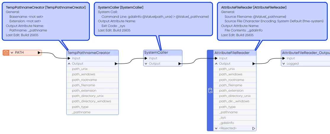
I would like to use gdalinfo to read the metadata/header for a folder of rasterfiles to get the extent and of each file. Ggalinfo can read this without loading the raster itself. This greatly speeds up the process.
Can we use the gdal implementation of FME to do this and if so how? The goal is to also have this working on FME Flow.
Example of gdalinfo output:
gdalinfo "C:\path\to\file\1.img"
Driver: HFA/Erdas Imagine Images (.img)
Files: C:\path\to\file\1.img
Size is 200, 130
Origin = (209000.000000000000000,529000.000000000000000)
Pixel Size = (100.000000000000000,-100.000000000000000)
Metadata:
DataType=Generic
Corner Coordinates:
Upper Left ( 209000.000, 529000.000)
Lower Left ( 209000.000, 516000.000)
Upper Right ( 229000.000, 529000.000)
Lower Right ( 229000.000, 516000.000)
Center ( 219000.000, 522500.000)
Band 1 Block=64x64 Type=Float32, ColorInterp=Undefined
Description = Layer_1
Min=-54.770 Max=-21.170
Minimum=-54.770, Maximum=-21.170, Mean=-40.290, StdDev=6.935
NoData Value=-3.402823e+38
Metadata:
LAYER_TYPE=athematic
RepresentationType=ATHEMATIC
STATISTICS_COUNT=23044.000000
STATISTICS_COVARIANCES=48.09764641535641
STATISTICS_EXCLUDEDVALUES=
STATISTICS_MAXIMUM=-21.170000076294
STATISTICS_MEAN=-40.290237806175
STATISTICS_MEDIAN=-41.33
STATISTICS_MINIMUM=-54.770000457764
STATISTICS_MODE=0
STATISTICS_SKIPFACTORX=1
STATISTICS_SKIPFACTORY=1
STATISTICS_STDDEV=6.9352466729999
Image Structure Metadata:
COMPRESSION=RLE