Did you have a look at the ChangeDetector transformer? That is built for this kind of comparison.
And you have to keep in mind that different data formats can have different tolerances for coordinates. Usually the CoordinateRounder transformer is used to match the tolerances (number of decimals on the coordinates).
If using a CoordinatesRounder makes the job, you can store your geometries into an attribute BEFORE any CoordinatesRounder (GeometryExtractor) and restore them after your spatial filter with a GeometryReplacer
I strongly suspect that FGDB is a floating point format and Shapefile is integer-based. When FME converts the integer shapefile values to floating point (FME works in floating point), then there is a little rounding error. It's not a bug, just the nature of binary maths on a computer.
For example, coordinates that were (eg) 12345.6 in the Shapefile could now be 12345.5999999999 and so the coordinates don't match the FGDB (which is floating point already and so not affected).
Other products will hide this by rounding the values automatically. FME doesn't, so you would have to round the values off with a CoordinateRounder transformer. It shouldn't produce any more inaccuracies than other software. The rounding error is normally at the 12th decimal place (or something like that), way more precise than most spatial data. It's assumed you know the precision you want your data to be, and rounding it off to that point won't affect it.
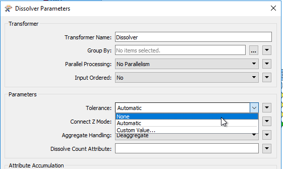
However... In the future, FME is getting a Tolerance parameter directly in many of the transformers. There are about 15 of these transformers in 2018:
No tolerance means you want the existing behaviour. Custom Value means you are going to enter a rounding value (just as in the CoordinateRounder). That will help in this situation but also be useful where the data is bad in itself.
Automatic means that FME is going to round the coordinates automatically. The exact mechanism I don't know off hand, but it will basically bring FME into line with tools that automatically round coordinates.
I hope that helps. I don't think the SpatialFilter is getting this behaviour in 2018, but I expect it will in a future release. I'm going to be writing up a blog post about this so keep an eye out for it on blog.safe.com
Mark
Actually I think it's the other way around in terms of format. eg Shapefile returns an x value of 492182.717 whereas FGDB returns 492182.7170000002 - but the issue is still the same that one is being rounded and you can see that rounding off to 3dp won't hurt my data.
I ended up using the UpdateDetector with a GeometryExtractor and GeometryReplacer either side of the CoordinateRounder - worked a treat, thanks.