Question

is there any way to set the coordinate system of tiff?


totree30
Contributor
Forum|alt.badge.img+3

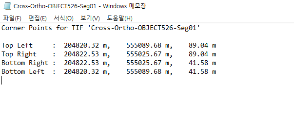
Hello! I just got ortho images from Realworks, but I got images without coordinate system and some information in txt format. Is there any way to put this txt file as a coordinate system in FME?

At last, I would like to get EPSG : 3857 geo referenced ortho images. 


5 replies

virtualcitymatt
Celebrity
Forum|alt.badge.img+36

You can set/define the input coordinate system in the reader. 

By default FME will try and read it from the input, but if none is detected then it will fall back to unknonw an you will need to define it. 

If you don’t know the coordinate system of the data then you could try a few different ones and check that the data are in the right place using FME and a background map. But the fastest/best way might be to contact the data provider and ask for the coordinate system.

For reprojecting you can use either the CSMapReprojector or the Reprojector transformer. 


nielsgerrits
VIP
Forum|alt.badge.img+54

You can put rasters on coordinates using the RasterGeoreferencer, based on the extents.


totree30
Contributor
Forum|alt.badge.img+3
  • Author
  • Contributor
  • March 4, 2024

Thank you for reply! The problem is, it doesn’t have a coordinate system,
I mean, my image has x,y,z value as you can see on the txt file, but in fme data inspector, it recognized the image as only x,y (starting from 0,0), and I think it is a default value.


totree30
Contributor
Forum|alt.badge.img+3
  • Author
  • Contributor
  • March 4, 2024

because my image is a texture of  buildings


hkingsbury
Celebrity
Forum|alt.badge.img+55
  • Celebrity
  • March 6, 2024

It’s possible those coordinates are a local coordinate system specific to the project that imagery was extract from in RealWorks (assumption, never used RealWorks - or heard of it before now)

https://pro.arcgis.com/en/pro-app/3.1/help/mapping/properties/coordinate-systems-and-projections.htm

The origin (0,0) of these coordinates will be defined at the project level. You’ll need to get in touch with whoever setup the project and find where (0,0) is in real world coordinates. You may need to reproject this coordinate into a meters based system (say if its wgs84-ll)

You can then use the offsetter to offset from that real world coordinate using your xy values then the coordinate system setter to set the rasters to the real world coordinate system. If thats not in 3857 then you will need to reproject the rasters as mentioned above


Cookie policy

We use cookies to enhance and personalize your experience. If you accept you agree to our full cookie policy. Learn more about our cookies.

 
Cookie settings