
Solved
I have two polygon shapefiles that I need to spatially join. I'm trying to populate township/range/section in my dataset based on a TRS shapefile. I have it working in ModelBuilder through ArcGIS but I can't get it to correlate the same in FME Desk

I have two polygon shapefiles that I need to spatially join. I'm trying to populate township/range/section in my dataset based on a TRS shapefile. I have it working in ModelBuilder through ArcGIS but I can't get it to correlate the same in FME Desktop.
Best answer by markatsafe
@m_stateland Thanks for attaching the data. The issue is that your boundaries do not match exactly. SpatialRelator is very exacting, so if you use the 'Within' predicate and the boundaries cross, even very slightly, the test will fail. If you use 'Intersects' then you might pickup the neighbouring TRS as well (getting two matches). So you have two options:
- clean the data to make sure the edges match then use SpatialRelator with a 'Within' predicate
- replace the ASLD features with an inside point and then do the spatial join with either SpatialRelator or PointOnAreaOverlayer.
I think I'd lean to the second option using PointOnAreaOverlayer.
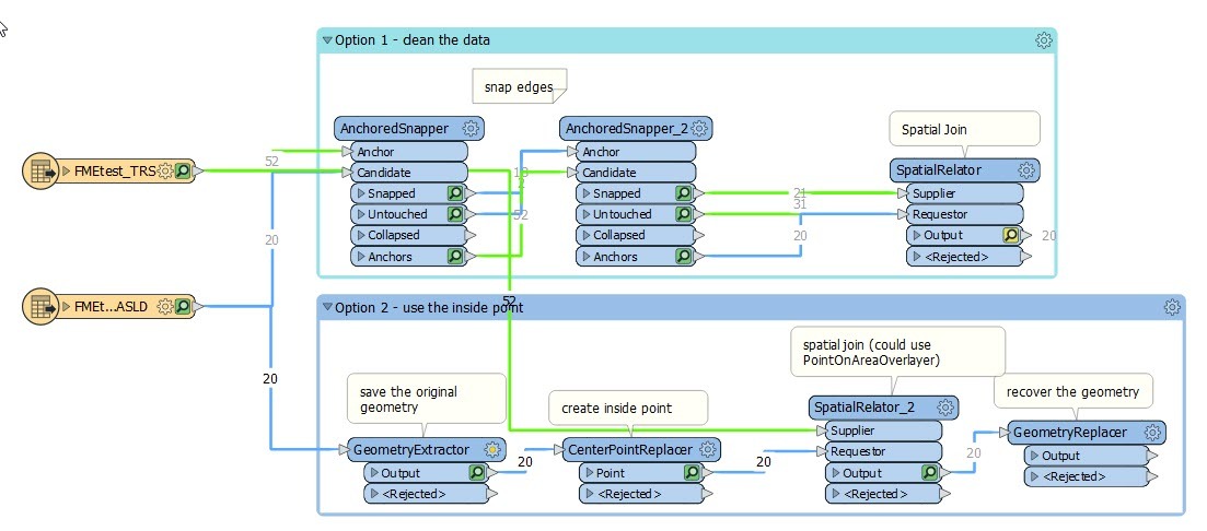
I've attached an example workspace (FME 2020.2.2)
(actually you could use a single Snapper instead of the two AnchorSnapper's)
This post is closed to further activity.
It may be an old question, an answered question, an implemented idea, or a notification-only post.
Please check post dates before relying on any information in a question or answer.
For follow-up or related questions, please post a new question or idea.
If there is a genuine update to be made, please contact us and request that the post is reopened.

Login to the community
No account yet? Create an account
An FME Account is required to contribute
LoginEnter your E-mail address. We'll send you an e-mail with instructions to reset your password.