Question

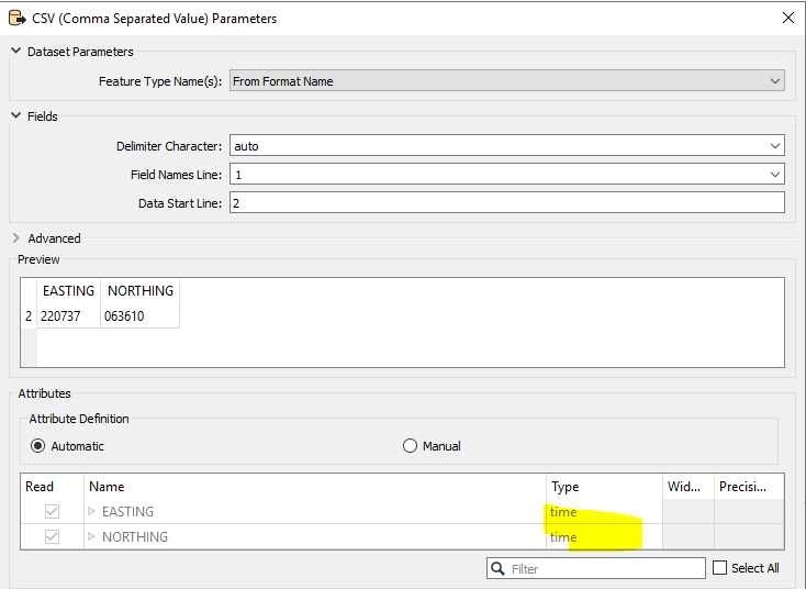
I am reading a csv file with easting and northing columns (British National Grid), however FME seems to be automatically changing them to Lat Long even though I have the projection set as EPSG:27700 or if I don't set a projection at all.

  • April 28, 2023
  • 3 replies
  • 71 views

ruth_h
Contributor
Forum|alt.badge.img+4

How do I stop it changing the entries in those fields so I can create points in the correct location please?

3 replies

daveatsafe
Safer
Forum|alt.badge.img+19
  • Safer
  • 1637 replies
  • April 28, 2023

Hi @ruth_h​,

Would you mind sharing a small section of that CSV file (perhaps two or three lines, plus the header)? It would be helpful to see your workspace as well.


ebygomm
Influencer
Forum|alt.badge.img+44
  • Influencer
  • 3422 replies
  • May 2, 2023

Check the Attribute Definition under the csv reader parameters, i suspect they are being incorrectly interpreted as time. Change the option to manual and you can then choose the type as x-coordinate and y-coordinateimage 


ruth_h
Contributor
Forum|alt.badge.img+4
  • Author
  • Contributor
  • 11 replies
  • May 2, 2023

Thank you both for your replies. ebygomm - you are right, that's exactly it. It was annoying me so much but that fixes it. Thanks very much.