Question

How to get the elevation on the polygon?


Forum|alt.badge.img

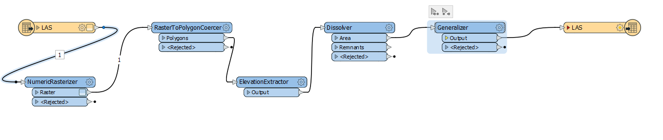
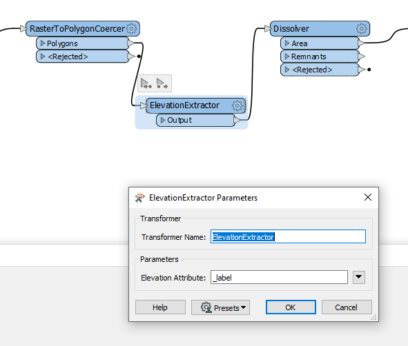
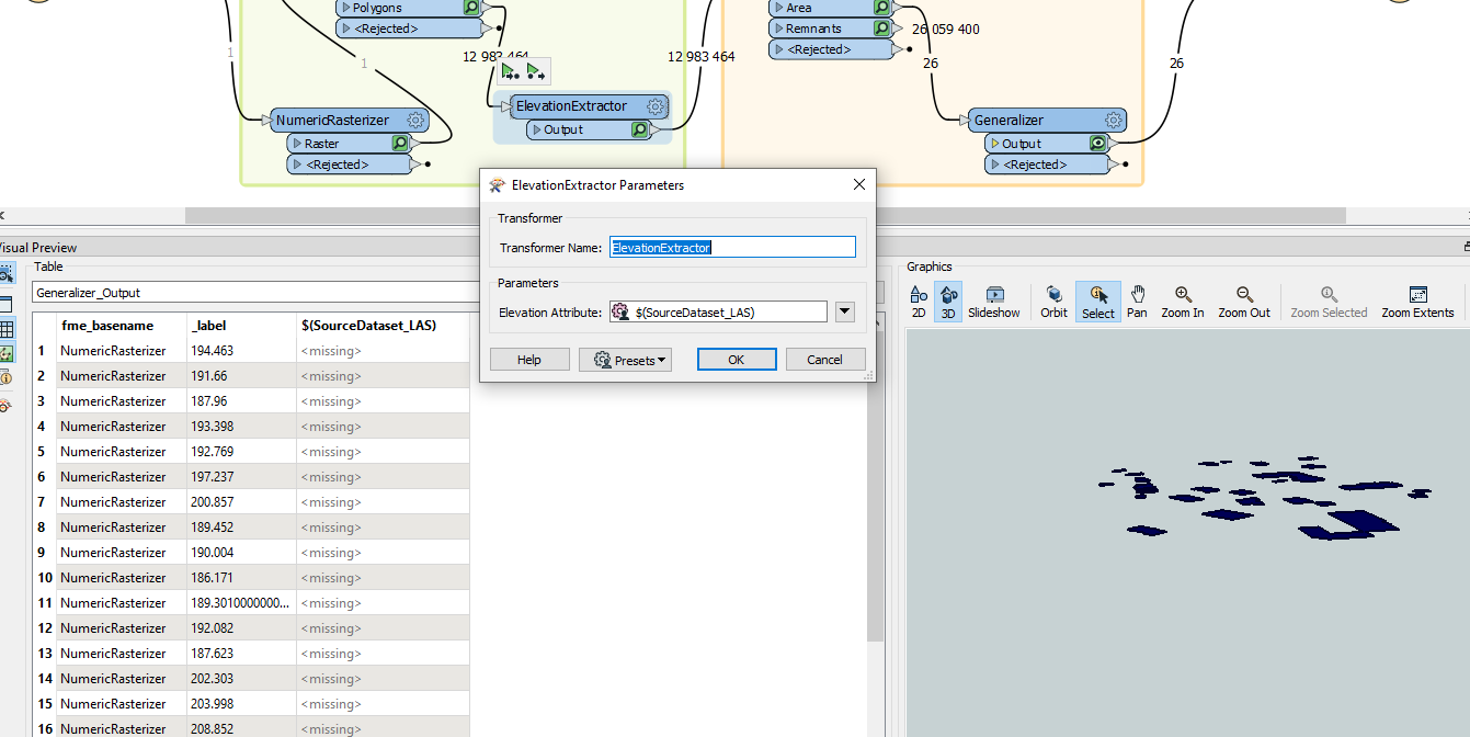
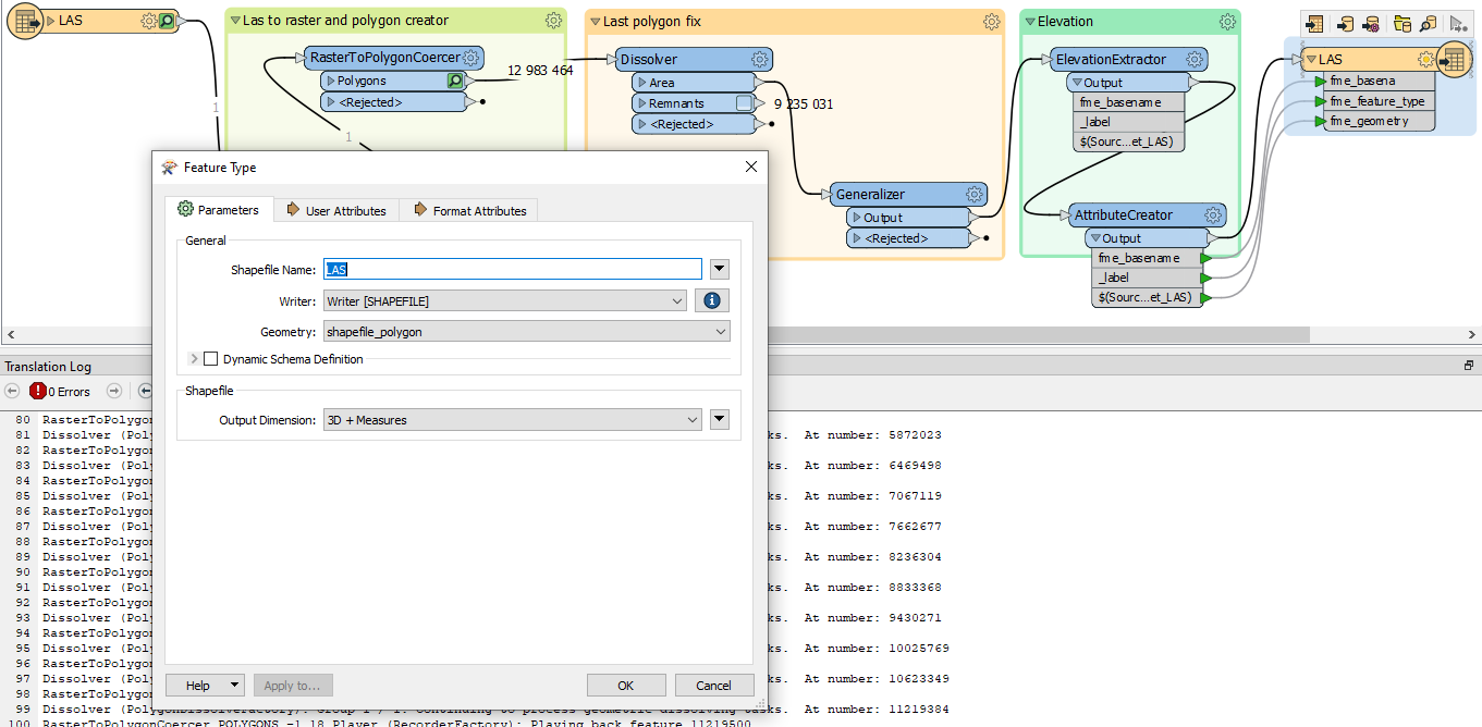
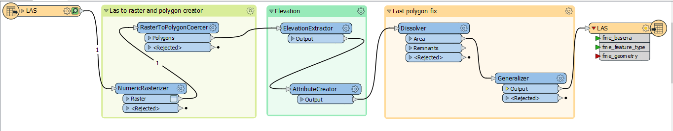
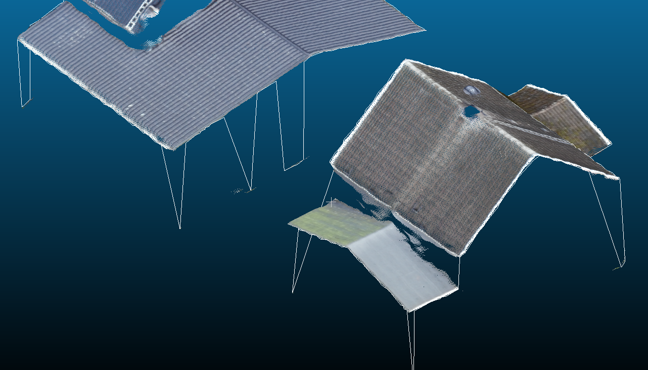
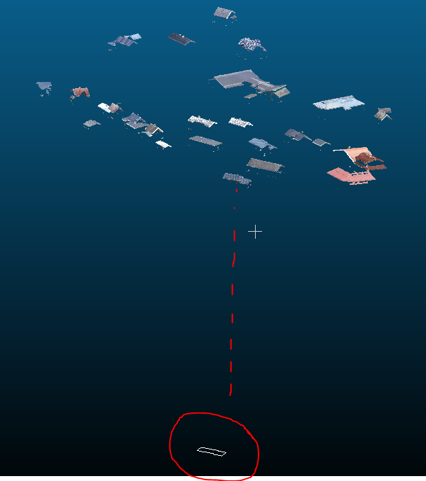
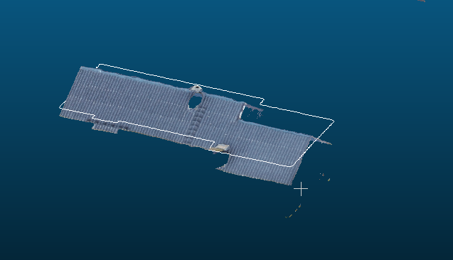
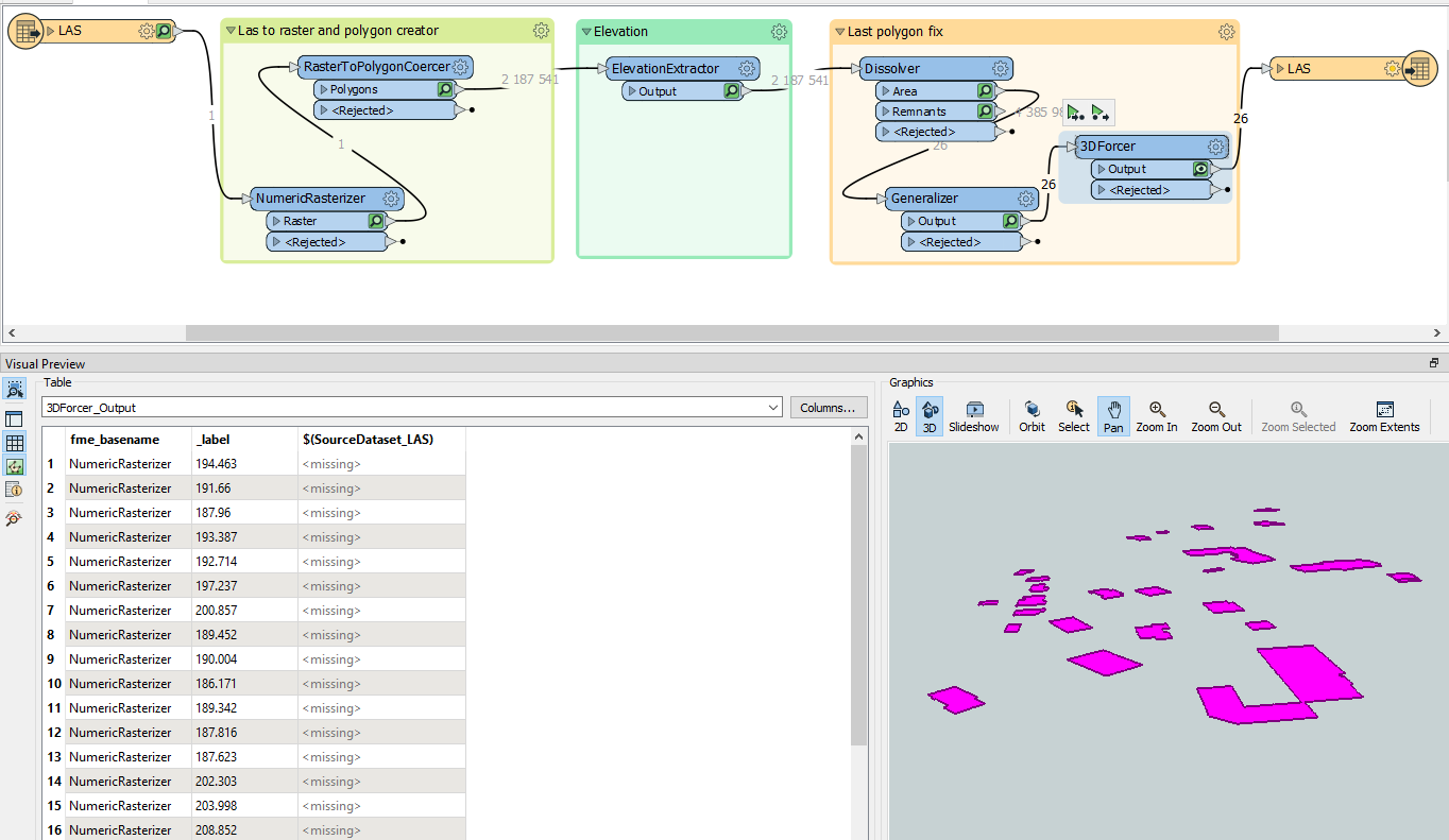
I have one problem with getting the right height of the polygons as shown here in CC.

Høydefeil

17 replies

Forum|alt.badge.img
  • Author
  • March 25, 2021

Attribute creator_V03


Forum|alt.badge.img
  • Author
  • March 25, 2021

This is my modell and everything is good intill Generalizer


Forum|alt.badge.img
  • Author
  • March 25, 2021

Is there som better way to get the elevation on each polygon? This picture is from the Generalizer and it is pretty nice just miss the elevation. Elevation is now 0.

polygon


nampreetatsafe
Safer
Forum|alt.badge.img+13

Is there an elevation on the features prior to the Generalizer? If so, you can try using the ElevationExtractor to get the elevation values into an attribute.


Forum|alt.badge.img
  • Author
  • March 30, 2021

Hello I tried the Elevation Extractor so my new aet up is like this:

new set up


Forum|alt.badge.img
  • Author
  • March 30, 2021

The other transformer like CoordinateExtraktor, AttributeCreator and 3Dforcer I removed. I am running the FME now so are awaiting the reult. The NumericRasterizer I set to 0.02 that is maximum resolution, this make the time it use on the process longer but I get mor elevation information and hopfully it can draw mor acurate polyline.


All of the transformer are doing as expected just I am not sure how to set up the ElevationExtractor. It is getting the elevation byt they are not taken on to the next transformer, so the Z value are set to 0.

ElevationExtractor


Forum|alt.badge.img
  • Author
  • March 30, 2021

When FME is ready I can show the log


Forum|alt.badge.img
  • Author
  • March 31, 2021

Hello this is standing in the log:

"Shapefile Writer: Feature type 'LAS' recieved a geometry that was modified to fit the selected dimensions of the output: Z coordinates have been set to default of 0. If this is unexpected, check the settings of the writer"


There har 11 warnings:

"Feature Caching is ON

The workspace may run slower because features are being recorded on all output ports.

NOT changing coordinate system of reader identified by keyword `LAS_1' from `UTM84-32N' to `NonEarth_Meter' -- mapping file setting of `UTM84-32N' overrides coordinate system `NonEarth_Meter' read from file

Shapefile Writer: Feature type 'LAS' recieved a geometry that was modified to fit the selected dimensions of the output: Z coordinates have been set to default of 0. If this is unexpected, check the settings of the writer

-~-~-~-~-~-~-~-~-~-~-~-~-~-~-~-~-~-~-~-~-~-~-~-~-~-~-~-~-~-~-~-~-~-~-~-~-~-~-~-~-

-~ ~-

-~ Feature caches have been recorded at every stage of the translation. ~-

-~ To inspect the recorded features, ~-

-~ click the feature cache icons next to the ports. ~-

-~ ~-

-~-~-~-~-~-~-~-~-~-~-~-~-~-~-~-~-~-~-~-~-~-~-~-~-~-~-~-~-~-~-~-~-~-~-~-~-~-~-~-~-

"


This is the end text:

Translation was SUCCESSFUL with 9 warning(s) (26 feature(s) output)

FME Session Duration: 15 hours 12 minutes 52.3 seconds. (CPU: 43163.1s user, 443.8s system)

END - ProcessID: 16368, peak process memory usage: 43182740 kB, current process memory usage: 213656 kB

Translation was SUCCESSFUL


Forum|alt.badge.img
  • Author
  • March 31, 2021

label


Forum|alt.badge.img
  • Author
  • March 31, 2021

I tryed to use the lasfile as source but it says it is missing the lasfile. When importing the file to CC program it says somthing missing and I get one polygon.


ElevationExtractor_02


caracadrian
Contributor
Forum|alt.badge.img+23
  • Contributor
  • March 31, 2021

Set the Output Dimension of the shape file to 3D+MeasuresShape with 3D


Forum|alt.badge.img
  • Author
  • March 31, 2021
caracadrian wrote:

Set the Output Dimension of the shape file to 3D+MeasuresShape with 3D

Thanks this I hawe got tip on previous, so there is somthing else I am doing wrong, here is my nev setup:

ElevationExtractor_04


Forum|alt.badge.img
  • Author
  • March 31, 2021
slakern0 wrote:

Thanks this I hawe got tip on previous, so there is somthing else I am doing wrong, here is my nev setup:

ElevationExtractor_04

I wonder iv elevation should be before disolver, I tryed this too but dont change anything.


Forum|alt.badge.img
  • Author
  • March 31, 2021

I run this now because I get up after <RasterToPolygoneCoercer> that Z values are set to 0, so then I try to get them back, create an attribute for so and only stand again with polygon around the building.

ElevationExtractor_05


Forum|alt.badge.img
  • Author
  • March 31, 2021

Finely I got a bit closer but it is not perfekt and it is missing the rest of the polygone.almostElevationExtractor_06


Forum|alt.badge.img
  • Author
  • March 31, 2021

Are the other setting I can use?


Forum|alt.badge.img
  • Author
  • March 31, 2021

Hello I finely figure oute the problem and the moddel ar adjusted again by putting the 3Dforce after the elevation ekstraktor and it this was the solotion. I have som problem in my lasfile withe noise but I am going too use the dont hull and areal calulator to remowe this noise. Hope that wil do it. Then Thanks for the help It realy get one more step closer.

Here is the result so far by the way:

støy


Cookie policy

We use cookies to enhance and personalize your experience. If you accept you agree to our full cookie policy. Learn more about our cookies.

 
Cookie settings