Question

How can I generate a JPEG image from multiple MapInfo layers from within FME

  • October 21, 2019
  • 2 replies
  • 116 views

jnotter
Contributor
Forum|alt.badge.img+5

I have several MapInfo map layers that I want to generate and send to my client as an image. I see that https://community.safe.com/s/article/creating-pdf-cartographic-output offers a way to render as PDF, but is there a similar method to render multiple layers to a PDF? Ideally I would want render a report with several pieces:

  • An underlying map layer with streets, parks, terrain etc.
  • Highway layers for the major roads in the area
  • Custom elements layer, with labels
  • Sparse color-thematic grid overlay
  • Legend for the color thematic
  • Additional footer for some standard text information.

And some alpha transparency to a couple of the layers.

2 replies

deanhowell
Influencer
Forum|alt.badge.img+23
  • Influencer
  • October 22, 2019

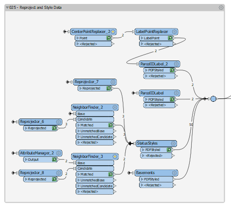
Hello @jnotter, I do a similar thing but from CAD drawings.

The screenshot of the image below takes input from a number of layers, reprojects some and adds style and then creates the PDF.


Hope that helps a little.


erik_jan
Contributor
Forum|alt.badge.img+18
  • Contributor
  • October 31, 2019

Have a look at the MapnikRasterizer transformer.

That transformer can do the styling and creates a raster object from vector and/or raster data.

Hope this helps.


Cookie policy

We use cookies to enhance and personalize your experience. If you accept you agree to our full cookie policy. Learn more about our cookies.

 
Cookie settings