Question

Geometry simplify


Forum|alt.badge.img

Hi FME community,


I need help to do one little thing:


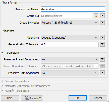
I have a request to simplify the geometries I processed with a tolerence of 0.5 meter

The geometries come from two tables and at the end they are saved as Geometrycollection (with aggregator).


Thanks for you help...


5 replies

david_r
Celebrity
  • May 14, 2020

Have you already looked at the Generalizer? There's also a derived version of it on the FME Hub called the GeographicGeneralizer that may be helpful in this particular case.

If the data has a topology that needs to be preserved, also look at the SherbendGeneralizer.


Forum|alt.badge.img
david_r wrote:

Have you already looked at the Generalizer? There's also a derived version of it on the FME Hub called the GeographicGeneralizer that may be helpful in this particular case.

If the data has a topology that needs to be preserved, also look at the SherbendGeneralizer.

@david_r thanks for your answer.


I read some posts with the "Generalizer" but I don't now how to implement it correctly.


The feature SRID is 31370(Lamb72) so I guess that it's meter unit... so in the Generalizer I put 0.5 in the parameters:


Is it the right way to do ?


In the inspector , there is a line with 44 coordinates and after the Generalizer it's 5. Could it be possible ?

david_r
Celebrity
  • May 14, 2020
stephme2021 wrote:

@david_r thanks for your answer.


I read some posts with the "Generalizer" but I don't now how to implement it correctly.


The feature SRID is 31370(Lamb72) so I guess that it's meter unit... so in the Generalizer I put 0.5 in the parameters:


Is it the right way to do ?


In the inspector , there is a line with 44 coordinates and after the Generalizer it's 5. Could it be possible ?

The Generalizer is surprisingly complex and the results can vary wildly depending on the configuration and the input data, so I would strongly recommend to read through the documentation first, if you haven't already: https://docs.safe.com/fme/html/FME_Desktop_Documentation/FME_Transformers/Transformers/generalizer.htm


redgeographics
Celebrity
Forum|alt.badge.img+49
stephme2021 wrote:

@david_r thanks for your answer.


I read some posts with the "Generalizer" but I don't now how to implement it correctly.


The feature SRID is 31370(Lamb72) so I guess that it's meter unit... so in the Generalizer I put 0.5 in the parameters:


Is it the right way to do ?


In the inspector , there is a line with 44 coordinates and after the Generalizer it's 5. Could it be possible ?

Depending on what your line looks like it's perfectly possible to go from 44 to 5 coordinates (if it's rather straight and you set the tolerance high enough it'll go down to just 2). You need to take a look at the results and consider whether they look good enough.

Different algorithms have different results and different settings. Sometimes you need to combine them (run 2 Generalizers, one after the other).


erik_jan
Contributor
Forum|alt.badge.img+17
  • Contributor
  • May 14, 2020

The CoordinateRounder could be used to round the coordinates to a number of decimals.

But that would round in your case either to 0 or 1 decimal, which is a meter of decimeter if your data is in meters.


Cookie policy

We use cookies to enhance and personalize your experience. If you accept you agree to our full cookie policy. Learn more about our cookies.

 
Cookie settings