
Hello,
I'm scraping data using an HTTPCaller.
One of the attributes contains GeoJSON data:
{"type":"FeatureCollection","features":[{"type":"Feature","properties":{},"geometry":{"coordinates":[[[5.96266096723135, 51.9996241913007],[5.96267141231219, 51.9996290142943],[5.96315710713663, 51.999175649922],[5.96290120337337, 51.9991708268575],[5.96266096723135, 51.9996241913007]]],"type":"Polygon"}}]}
I'd like to visualize these polygons in the Data Inspector but I don't know how to convert this data into an actual polygon.
What transformers do I need?
Thanks

Solved
How to visualize GeoJSON data?
 +2
+2- Contributor
Best answer by takashi
Hi
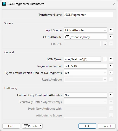
JSONFragmenter with these parameters might help you.
- JSON Query: json[“features”][*]
- Fragment as Format: GEOJSON
This post is closed to further activity.
It may be an old question, an answered question, an implemented idea, or a notification-only post.
Please check post dates before relying on any information in a question or answer.
For follow-up or related questions, please post a new question or idea.
If there is a genuine update to be made, please contact us and request that the post is reopened.


Login to the community
No account yet? Create an account
An FME Account is required to contribute
LoginEnter your E-mail address. We'll send you an e-mail with instructions to reset your password.