The issue I am seeing is geometry/spatial distortion between two different formats, .shp and .tab when converting from a spatial oracle table.

I am currently using FME 2015.

The spatial metadata for oracle has set bounds and the same spatial extent was set for min/max x/y for the .tab writer. Below, the distortion is quite evident.

Red: .tab with no spatial bounds


Green: .tab with same spatial bounds as oracle spatial metadata


Blue: Shapefile

I have tried to restrict the spatial extent to a smaller area in the .tab format but the distortion is still evident (see below). The distortion improved but it is not consistent.
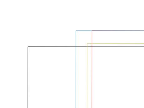
Black: .tab output with original spatial extent, same as oracle spatial metadata.


Blue: .tab with spatial extent changed to another smaller area.


Green: Shapefile output with original spatial extent, same as oracle spatial metadata


Red: .tab with spatial extent changed to the smallest area possible.

Is there a way to minimise or if possible, remove the distortion?

Hi @matkins

what is your MapInfo coordinate system and what are the extents? And how big is the error?

It is quite possible that MapInfo can not handle this data with high precision due to too big extents. Then... the only solution I can think of right away would be to split the data into multiple tables and write them all with the same coordinate system but with different extents. This doesn't sound ideal, but if you are dealing with MapInfo limitation there might be no other options.

Hi @LenaAtSafe,


The writer MapInfo coordinate system is inherited as the reader (GDA94) (it is not set within the writer) and the extents was originally set to min x = 96, min y = -45, max x = 169 and max y = -8.


Should I also set the coordinate system within the writer as well?


I restricted or made the extent as small as possible to what it was bounding to/within, to min x = 112.75, min y = -43.95, max x = 159.40 and max y = -9.05.


I knew of the limitations to precision regarding MapInfo, I was just curious if anyone else has dealt with the same issue and was able to work around it without to much geometry manipulation.


There are several GDA94 coordinate systems in the Coordinate System Gallery. Could you please check which one is the one you need (please see coordinate system Properties), set it explicitly on the MapInfo Writer, and run the translation again? I wonder if a coordinate system with slightly different parameters is used.


There are several GDA94 coordinate systems in the Coordinate System Gallery. Could you please check which one is the one you need (please see coordinate system Properties), set it explicitly on the MapInfo Writer, and run the translation again? I wonder if a coordinate system with slightly different parameters is used.


@LenaAtSafe, including the coordinate system did see a significant decrease in distortion.2017-10-24-14-10-22.jpg


Orange - No bounds set, inherited coordinate system.


Blue - Original bounds


Red - Shapefile


Black - New bounds and set coordinate system.


@LenaAtSafe, including the coordinate system did see a significant decrease in distortion.2017-10-24-14-10-22.jpg


Orange - No bounds set, inherited coordinate system.


Blue - Original bounds


Red - Shapefile


Black - New bounds and set coordinate system.


Is it a good enough precision now?


Is it a good enough precision now?


Yes, as close as it can be.


Thank you @LenaAtSafe
Yes, as close as it can be.


Thank you @LenaAtSafe
Perfect! I am glad :)


Reply