Question

Elevation Profile

  • January 11, 2018
  • 2 replies
  • 65 views

Forum|alt.badge.img

Hi!

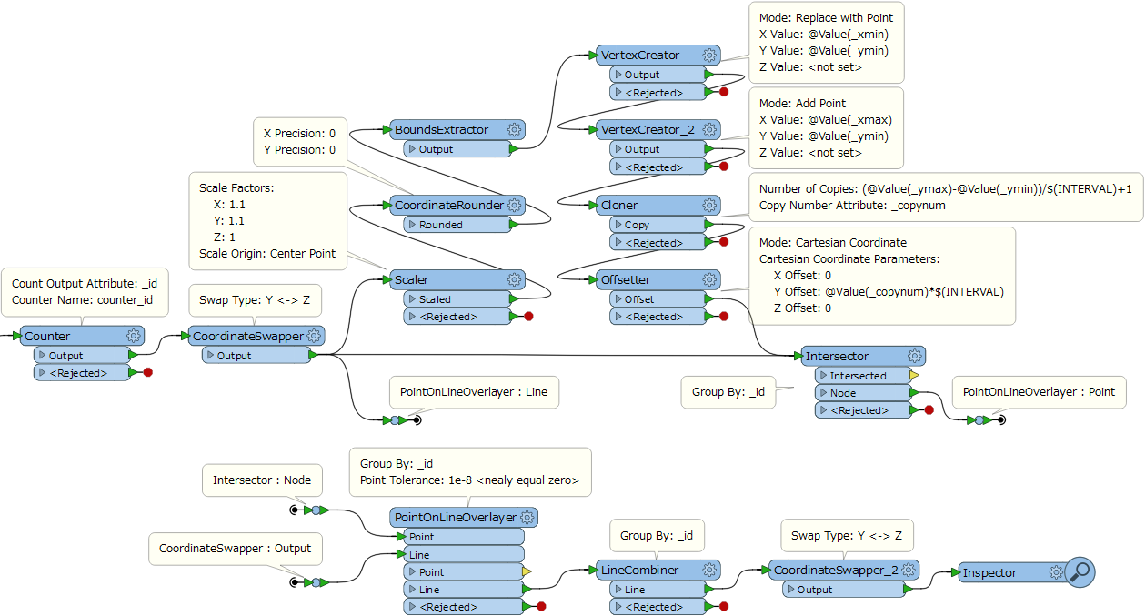
I have a lot of elevation profiles. These profiles have polyline geometry. I want to add additional vertices to profile lines with custom step of elevation (f.e. each 1 meter of elevation).

Do you have any ideas how to do this task?

Many thanks beforehand!

This post is closed to further activity.
It may be an old question, an answered question, an implemented idea, or a notification-only post.
Please check post dates before relying on any information in a question or answer.
For follow-up or related questions, please post a new question or idea.
If there is a genuine update to be made, please contact us and request that the post is reopened.

2 replies

takashi
Celebrity
  • 7843 replies
  • January 11, 2018

Hi @sega, if I understood your requirement correctly, this procedure could be a solution.

  1. Swap the Y and Z coordinates of the line (CoordinateSwapper).
  2. Create equi-interval horizontal lines which cover the source line. Here, the Y axis direction is equivalent to the original Z axis direction, since the Y and Z coordinates of the line have been swapped at first.
  3. Generate all cross points between the source line and the horizontal lines (Intersector).
  4. Split the source line at the cross points (PointOnLineOverlayer).
  5. Recombine the split line into a single line (LineCombiner).
  6. Swap the Y and Z coordinates of the line to restore the original axes (CoordinateSwapper).


  • 2 replies
  • April 16, 2020

Hi @sega, if I understood your requirement correctly, this procedure could be a solution.

  1. Swap the Y and Z coordinates of the line (CoordinateSwapper).
  2. Create equi-interval horizontal lines which cover the source line. Here, the Y axis direction is equivalent to the original Z axis direction, since the Y and Z coordinates of the line have been swapped at first.
  3. Generate all cross points between the source line and the horizontal lines (Intersector).
  4. Split the source line at the cross points (PointOnLineOverlayer).
  5. Recombine the split line into a single line (LineCombiner).
  6. Swap the Y and Z coordinates of the line to restore the original axes (CoordinateSwapper).

Hello Mr. @takashi, I'd like to ask you how to extract multiple las from one by their elevation values, e.g. one would be from 2 to 4 meters, then 4-8, 8-10 and so on. A very simple tool would be great. I am working on forest point clouds, I need to access different strata, thank you in advance!