Question

Create & Update attribute on point file from polygon data

  • December 5, 2017
  • 4 replies
  • 147 views

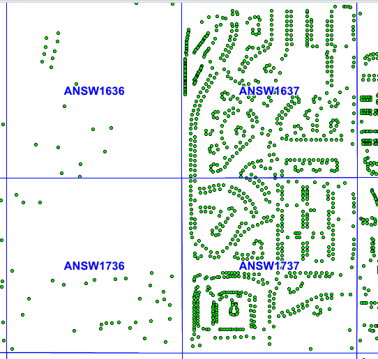
I downloaded a point shapefile and want to add new attributes and update them depending on what boundary they fall within. In this case, I have a pre-existing MapInfo Table of grids in a city.

I want the green points to have a new attribute with what grid they are in. So the points in the upper left would have ANSW1636 in it.

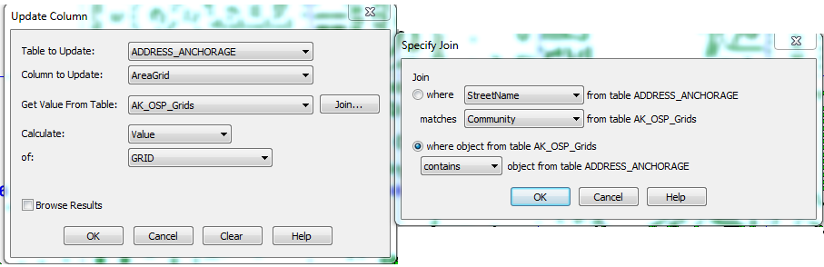
Usually I would manually create the new attribute in the table within MapInfo and then update the field using their Update Column feature like below.

I'm a fairly new user of FME and am not sure what an easy way to do this is. Also I am using FME 2013 so I won’t have any of the fancy new features after that version.

This post is closed to further activity.
It may be an old question, an answered question, an implemented idea, or a notification-only post.
Please check post dates before relying on any information in a question or answer.
For follow-up or related questions, please post a new question or idea.
If there is a genuine update to be made, please contact us and request that the post is reopened.

4 replies

erik_jan
Contributor
Forum|alt.badge.img+22
  • Contributor
  • 2179 replies
  • December 5, 2017

The transformer to have a look at is the PointonAreaOverlayer.

It will add the attributes from the Area on the Points


takashi
Celebrity
  • 7843 replies
  • December 6, 2017

The transformer to have a look at is the PointonAreaOverlayer.

It will add the attributes from the Area on the Points

Agree. The PointOnAreaOverlayer does the trick.


Alternatively, the SpatialFilter or the Clipper can also be used here. You can get the same result from those transformers.


I expect that the SpatialFilter with the "For Filters Only" option set to the "Use Bounding Box" parameter could perform that the best performance, if every area can be considered as rectangle whose edges are exactly parallel to X, Y axes.


  • Author
  • 1 reply
  • December 7, 2017
Agree. The PointOnAreaOverlayer does the trick.


Alternatively, the SpatialFilter or the Clipper can also be used here. You can get the same result from those transformers.


I expect that the SpatialFilter with the "For Filters Only" option set to the "Use Bounding Box" parameter could perform that the best performance, if every area can be considered as rectangle whose edges are exactly parallel to X, Y axes.


I have a few other boundaries I need to do this with that are uniquely shaped so I guess I should stick to the PointOnAreaFilter. I will have to play with those features still as they sounds pretty useful. thanks!


takashi
Celebrity
  • 7843 replies
  • December 7, 2017
Agree. The PointOnAreaOverlayer does the trick.


Alternatively, the SpatialFilter or the Clipper can also be used here. You can get the same result from those transformers.


I expect that the SpatialFilter with the "For Filters Only" option set to the "Use Bounding Box" parameter could perform that the best performance, if every area can be considered as rectangle whose edges are exactly parallel to X, Y axes.


OK, but I would recommend you to check the Usage Note in the Help on the PointOnAreaOverlayer, especially if you have a lot of input features.