Question

Create point based on coordinates and distances from primary point


Hi,

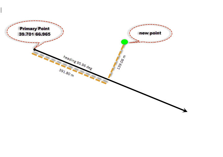
I need to create new point. I have coordinates in WGS84 of the primary point (declat 39.701, declon 66.965). Distance from primary point is 391.80 meters on the 95.69 degrees heading, and than second distance from this place is 139.06 meters on the heading 90 degrees. Could you please suggest me which transformations I should use? I tried with Offsetter but there is an issue with meters vs degrees.

Thank you!

Cinco

5 replies

  • Author
  • August 30, 2017

I attached picture for reference.


erik_jan
Contributor
Forum|alt.badge.img+18
  • Contributor
  • August 30, 2017

I believe at this moment the Offsetter is the transformer you need.

So, to use the meters offset you will need to reproject your data to a coordinate system in meters (Reprojector), do the offset and then reproject your data back to the original coordinate system.

You can store the original coordinate system using the CoorinateSystemExtractor.


mark2atsafe
Safer
Forum|alt.badge.img+46
  • Safer
  • August 30, 2017
erik_jan wrote:

I believe at this moment the Offsetter is the transformer you need.

So, to use the meters offset you will need to reproject your data to a coordinate system in meters (Reprojector), do the offset and then reproject your data back to the original coordinate system.

You can store the original coordinate system using the CoorinateSystemExtractor.

I would use the coordinate system _AZMEA_ or _AZMED_ in this case (probably _AZMED_ since you are working with lines). That's because it is an equal distance coordinate system. Then you can carry out the offset in metres and reproject back.


fmelizard
Safer
Forum|alt.badge.img+19
  • Safer
  • August 30, 2017
erik_jan wrote:

I believe at this moment the Offsetter is the transformer you need.

So, to use the meters offset you will need to reproject your data to a coordinate system in meters (Reprojector), do the offset and then reproject your data back to the original coordinate system.

You can store the original coordinate system using the CoorinateSystemExtractor.

The Offsetter can perform offsets with Polar Coordinates which may help in your case here.


pratap
Contributor
Forum|alt.badge.img+11
  • Contributor
  • August 31, 2017

Have you tried AttributeReprojector for calculation of values between different coordinate systems?


Cookie policy

We use cookies to enhance and personalize your experience. If you accept you agree to our full cookie policy. Learn more about our cookies.

 
Cookie settings