Question

How to overrule GeoPDF coordinatesytems


meijer
Contributor
Forum|alt.badge.img+3

The next screenshot is reading a corrupt geospatialPDF.

Result: It gets the page points, at the well known zero-island. The extent shows the points (~pixels if you like) of the original pdf. 595x842pt 

Capture
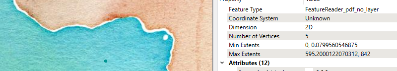
I know the coordinate system. LL84. Therefore I could overrule the coordinate system. But what happens is that the reader thinks there is no coordinate system. Therefore everything is considered page-points(595x842) And these coordinates are treated as lat,lngs. Projecting this geometry all over the ("edges" of the) world

CaptureThe settings of the reader:

The behavior of the first option would be in my mind.

Geospatial (if possible or over ruled).

 CaptureIs this a known limit and is there a way to read such document anyways with the right coordinates?

2 replies

debbiatsafe
Safer
Forum|alt.badge.img+20
  • Safer
  • December 11, 2020

Hi @meijer​ 


Unfortunately, the documentation notes that:

For content objects within a geospatial map frame, the reader will produce features with geospatial coordinates and coordinate system. If no map frames exists, or if a content object is not within any map frame, then features will be produced with coordinate in page points.


It seems like the features were not written within a map frame if you are getting features in page points when read in FME. You could try using a CoordinateSystemSetter, then offsetting/scaling if you know the area where the features are located but your coordinates will very likely not be in the correct location.


meijer
Contributor
Forum|alt.badge.img+3
  • Author
  • Contributor
  • December 11, 2020

Hi Debbi,


Thank you for your answer. I added the coordinate system that I can read from the geoPDF.

It seems that there is a map extent, but one that FME cannot read/recognize. (I guess the datum is unknown?)

It is good to know that QGIS can read the PDF without any problems


PROJCRS["Transverse_Mercator",

  BASEGEOGCRS["GCS_GRS 1980(IUGG, 1980)",

    DATUM["D_unknown",

      ELLIPSOID["GRS80",6378137,298.257222101,

        LENGTHUNIT["metre",1,

          ID["EPSG",9001]]]],

    PRIMEM["Greenwich",0,

      ANGLEUNIT["Degree",0.0174532925199433]]],

  CONVERSION["unnamed",

    METHOD["Transverse Mercator",


Cookie policy

We use cookies to enhance and personalize your experience. If you accept you agree to our full cookie policy. Learn more about our cookies.

 
Cookie settings