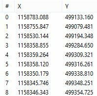
I have 2 datasets one has been loaded into a enterprise database and then exported with the object_id of the enterprise database. I am trying to spatially join this object_id back to the original data. The problem I am having is that the process of loaded and then exporting the data has changed the coordinates slightly. See images below. I am wondering if there is any way of manipulating the coordinates of the features (ie truncating some or all of the digits after the decimal) So that I can use the spatialrelator with the EQUALS test. I have some polygons that are with in polygons so buffering and using WITHIN as some other posts have suggested would not be ideal.
Polygon A
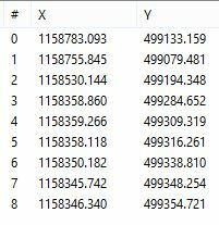
Polygon B