Question

Convert Coordinate from pseudo Mercator to Geographic Coordinate System in Shape file

  • 6 September 2017
  • 10 replies
  • 45 views

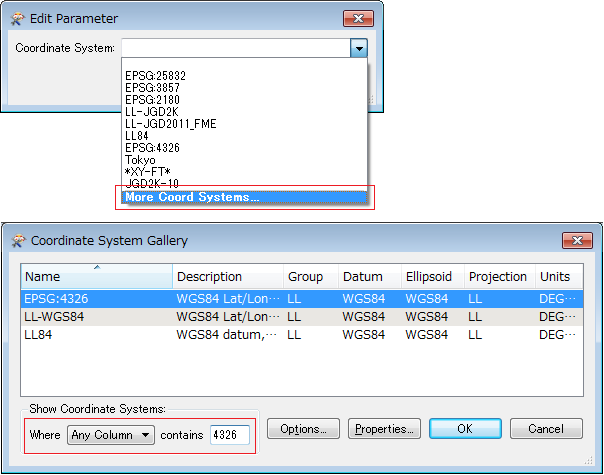
i m converting georss file to shapefile. But when i convert my all georss file to shapefile and i check the data it goes shifted from its position. i m using coordinate converter transformer but it show error. without this transformer file converts to shapefile. Data is 15 km shifting from its original position. Pls Help


10 replies

Badge +7

Could you share (a part of) the GeoRSS file with us? And tell us what coordinate system you want to reproject to?

By the way, you actually don't need to use a Reprojector transformer. You can also set the desired output Coordinate System on your Shapefile writer in the Navigator pane on the left.

Could you share (a part of) the GeoRSS file with us? And tell us what coordinate system you want to reproject to?

By the way, you actually don't need to use a Reprojector transformer. You can also set the desired output Coordinate System on your Shapefile writer in the Navigator pane on the left.

i m using this writer. coordinate-3.jpg


when i set coordinate to shapefile writer it shows Fatal error.


coordinate-2.jpg


Check the log file. log-file.txt


i also tried projector it also shows same error in log file. coordinate system does not exist


Userlevel 2
Badge +17

Hi @sonekarneelesh,

There seems to be a typo in the source coordinate system, so FME is reporting that it doesn't exist, and not performing the reprojection. Please set it to EPSG:4326 instead of EPSG4326. You can also leave it blank, and FME will automatically read the coordinate system defined in the GeoRSS data.

@DaveAtSafe i already do that same error......Coordinate system named EPSG4326 does not exist. and when i leave it blank data is successfully converted but it is 15 kilometers shifted from its original position.......


Userlevel 2
Badge +17
@DaveAtSafe i already do that same error......Coordinate system named EPSG4326 does not exist. and when i leave it blank data is successfully converted but it is 15 kilometers shifted from its original position.......


Hi @sonekarneelesh,


If no reprojection is done, the coordinates in the output Shape file will be identical to those in the source GeoRSS file. What dataset are you comparing the resulting Shape against to see the shift, and in what application?


Userlevel 2
Badge +17
@DaveAtSafe i already do that same error......Coordinate system named EPSG4326 does not exist. and when i leave it blank data is successfully converted but it is 15 kilometers shifted from its original position.......


Re-read carefully @DaveAtSafe's answer.


"Please set it to EPSG:4326 instead of EPSG4326"


You have to insert : between 'EPSG' and '4326'.


FME only recognizes coordinate system names listed in the Name column of the Coordinate System Gallery. You can set a valid coordinate system name by searching and selecting it in the Coordinate System Gallery.


@takashi i tried it but nothing happens my data is still 15 km shift from my original file.


polygon.jpg. Red Polygon is georss file converted to shapefile and in background my original file. Red Polygon is 15 km shifted from its position.
Hi @sonekarneelesh,


If no reprojection is done, the coordinates in the output Shape file will be identical to those in the source GeoRSS file. What dataset are you comparing the resulting Shape against to see the shift, and in what application?


@DaveAtSafe i m using QGIS to open my data. My original Data is in EPSG:4326 and the georss file is also in same coordinate. i tried some combinations like :-


EPSG:3857 to EPSG:4326


EPSG:4326 to EPSG:4326


but nothing happens.......


Userlevel 2
Badge +17
@DaveAtSafe i m using QGIS to open my data. My original Data is in EPSG:4326 and the georss file is also in same coordinate. i tried some combinations like :-


EPSG:3857 to EPSG:4326


EPSG:4326 to EPSG:4326


but nothing happens.......


Hi @sonekarneelesh


What is the original data you are comparing against? I added both the GeoRSS feed and the Shape file output by FME to QGIS, and they seem to overlay OK.
Userlevel 2
Badge +17
@takashi i tried it but nothing happens my data is still 15 km shift from my original file.


polygon.jpg. Red Polygon is georss file converted to shapefile and in background my original file. Red Polygon is 15 km shifted from its position.
I only suggested a way to set valid name of a coordinate system, and haven't mentioned anything about the 15 km shifting...


Reply