Solved

PointOnAreaOverlayer not working


benvk
Contributor
Forum|alt.badge.img+7
  • Contributor

I have a basic workbench where I have points stored in an ESRI ArcGIS Online Point Feature Layer, and I have an ESRI Enterprise SDE Polygon Feature Class. 99% of my AGOL points fall within a SDE polygon.


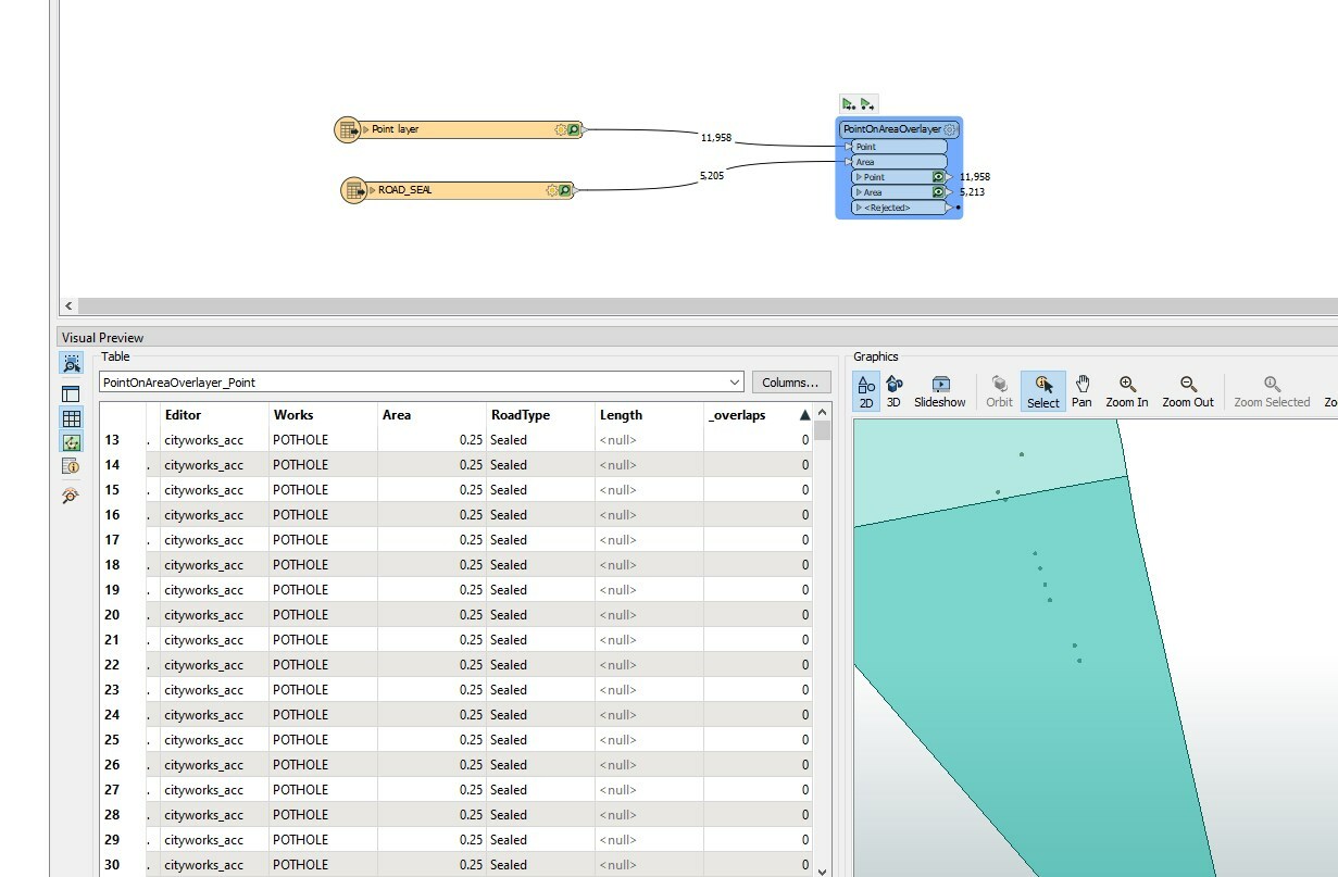
I have created a simple workbench with two readers (AGOL and SDE as previously described), as my screenshot shows, the points fall within the polygon areas, but the tool is not returning a single overlap whereby a point sits on a polygon, yet the screenshot clearly shows the point within the polygon. See '_overlaps' column in screenshot are all 0


Is there something basic I am missing? I just want each point to have an attribute outlining the polygon it is within.


2022-03-31 23_11_03-Window

Best answer by redgeographics

Are you sure both datasets are in the same coordinate system? Only then will the PointOnAreaOverlayer overlay them properly (the fact that the Visual Preview shows them as overlapping does not mean they're in the same coordsys)

View original
Did this help you find an answer to your question?

6 replies

redgeographics
Celebrity
Forum|alt.badge.img+50
  • Celebrity
  • Best Answer
  • March 31, 2022

Are you sure both datasets are in the same coordinate system? Only then will the PointOnAreaOverlayer overlay them properly (the fact that the Visual Preview shows them as overlapping does not mean they're in the same coordsys)


benvk
Contributor
Forum|alt.badge.img+7
  • Author
  • Contributor
  • March 31, 2022
redgeographics wrote:

Are you sure both datasets are in the same coordinate system? Only then will the PointOnAreaOverlayer overlay them properly (the fact that the Visual Preview shows them as overlapping does not mean they're in the same coordsys)

That's a good point, the ArcGIS online stuff would have been captured using the ESRI international collector app, but our SDE road segments are stored in local Australian MGA zone 55. I must be able to reproject them to be the same.

I must admit that the ​visual preview made me think they were already overlapping!! That's a trap for new players!


redgeographics
Celebrity
Forum|alt.badge.img+50
benvk wrote:

That's a good point, the ArcGIS online stuff would have been captured using the ESRI international collector app, but our SDE road segments are stored in local Australian MGA zone 55. I must be able to reproject them to be the same.

I must admit that the ​visual preview made me think they were already overlapping!! That's a trap for new players!


It certainly is. When you spatially combine two or more streams of data in FME, e.g. by doing an overlay, FME is going to assume all the coordinates are in the same "space", so it's up to you as the workspace author to make sure they are.


benvk
Contributor
Forum|alt.badge.img+7
  • Author
  • Contributor
  • March 31, 2022
benvk wrote:

That's a good point, the ArcGIS online stuff would have been captured using the ESRI international collector app, but our SDE road segments are stored in local Australian MGA zone 55. I must be able to reproject them to be the same.

I must admit that the ​visual preview made me think they were already overlapping!! That's a trap for new players!


What is the most efficient way for me to define both input datasets​, so they can be compared with the overlapper?


redgeographics
Celebrity
Forum|alt.badge.img+50
benvk wrote:

That's a good point, the ArcGIS online stuff would have been captured using the ESRI international collector app, but our SDE road segments are stored in local Australian MGA zone 55. I must be able to reproject them to be the same.

I must admit that the ​visual preview made me think they were already overlapping!! That's a trap for new players!


You can use a Reprojector (or ESRIReprojector) to reproject one of the datasets to the coordinate system of the other. To find out what they are you can check the feature caches of the input data, if you select a single feature and check the Feature Information panel you'll see which one it is.


benvk
Contributor
Forum|alt.badge.img+7
  • Author
  • Contributor
  • March 31, 2022
benvk wrote:

That's a good point, the ArcGIS online stuff would have been captured using the ESRI international collector app, but our SDE road segments are stored in local Australian MGA zone 55. I must be able to reproject them to be the same.

I must admit that the ​visual preview made me think they were already overlapping!! That's a trap for new players!


Fantastic, its working perfectly now, thanks for your help.


Cookie policy

We use cookies to enhance and personalize your experience. If you accept you agree to our full cookie policy. Learn more about our cookies.

 
Cookie settings