Question

I'd like to be able to identify polygons from one dataset that touch a polygon from a different dataset then tag that the polygon touches on one (or multiple( edges.


Forum|alt.badge.img

Hi.

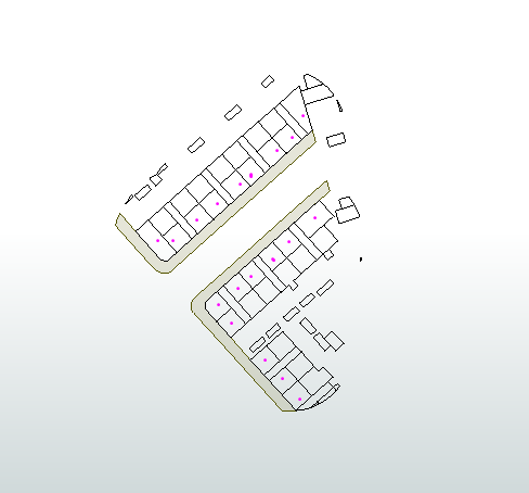
The image below is an extract from a much larger dataset. The image shows:

  • Vegetation as the green polygon
  • Buildings as hollow fill polygons


The polygons are on two different datasets and have been built in such a way that the edge between the two polygons are 'edge to edge'.


I need to be able to identify those buildings that 'touch' the vegetation polygon which I have identified with the red dot.

imageIt's been a while since I had to use this type of analysis and after searching the FME forum I'm still stuck. I guess could be overcomplicating my thought process. I know MapInfo has the functionality to do this but wanted to learn FME's approach.


Any help would be very much appreciated.

2 replies

Forum|alt.badge.img+2

@jez​ FME has several spatial join (webinar) tools. Merging or Joining Spatial Data is a good place to start, as well as the webinar link. I think I'd jump to the SpatialRelator but success will depend on how clean the data is.


Forum|alt.badge.img
  • Author
  • March 9, 2022
markatsafe wrote:

@jez​ FME has several spatial join (webinar) tools. Merging or Joining Spatial Data is a good place to start, as well as the webinar link. I think I'd jump to the SpatialRelator but success will depend on how clean the data is.

I knew there would be an appropriate transformer, marketsafe you are a star! The SpatialRelator with the Spatial Predicates to Test set to "Requestor OGC-Touches Supplier" works perfectly. Thankfully the data is in an excellent condition and this works perfectly.


Cookie policy

We use cookies to enhance and personalize your experience. If you accept you agree to our full cookie policy. Learn more about our cookies.

 
Cookie settings