
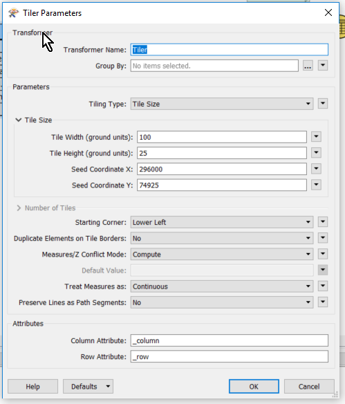
I have an ~80gb file that i need to split into around 15 files geographically into 25x100 strips.

https://knowledge.safe.com/articles/1100/tiling-point-cloud-data.html is helpful but FME will still read the whole file in one go. i only have 16-32GB of RAM (depending on computer im using) and so the computer will fall over. how can i split this file geographically and get around FME reading the whole file in one go?

You could use a workspace runner.


Use your parent workspace to split an area. Obtain the min and max extents and then feed these into the extent parameters (using published parameters) in the reader of the child workspace.

Would also enable you to run parallel processing.


I don't understand how this approach doesn't read the whole of the file in one go. 


This is what i have so far. 


  • The tiler is tiling on a set seed point (bottom left corner and making 25m x 100m strips) 
  • The snakegrid projector is currently not licensed but will be when i run the workspace.
  • I am fanning out the dataset on something like: @Value(fme_basename)_ @Value(_column)_@Value(_row).xyz


another problem (i guess unrelated) is that the workspace i have attached doesn't run still and comes up with an error as follows:


POINTCLOUDXYZ reader: Unexpected column name 'x'. When column names are not in the file, they are expected to be of the format 'colX' where X is a non-negative integer
0684Q00000ArJEPQA3.png


0684Q00000ArJ2RQAV.png


pointcloudxyz-esrishape2pointcloudxyz.fmw 


Reply