I am having trouble converting shape files into MapInfo and changing the projection from UTM to Long/Lat.  I have tried using FME, MapInfo Universal Translator, MapInfo Create Points.  I even tried creating long/lat fields in a table and then trying to Create Points.  But in all cases the files come up UTM in MapInfo not long lat even though the MapInfo default is Long/Lat.


Anyone with experience with FME and MapInfo that can help


kdmur
Hi,


try the following:


In the Workbench, go to File / New / Generate workspace.


Specify the translation something like this:


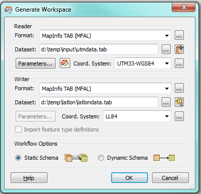
What is important here:
  • The coordinate system has been specified for BOTH the reader and the writer (you will have to use your own values here)
  • The output dataset is different from the input dataset (it will be created by FME)
Let us know if this doesn't work.


David

Reply