Question

Read Map Image Layer from Esri Portal


marta.podsiad
Supporter
Forum|alt.badge.img+9

Hi,

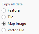
I would like to save a copy of Map Image Layer from Esri Portal into gdb. Esri ArcGIS Portal Feature Service does not recognise raster layers and ArcGISOnlineConnector does not recognise geomety. What is the way around?

6 replies

crutledge
Influencer
Forum|alt.badge.img+33
  • Influencer
  • June 30, 2025

Hi ​@marta.podsiad I have run into this on our Enterprise Portal. I plan to publish as wms to test whether I can use the wide range of ogc tools available. Is that an option on your side? To publish an additional wms beside your esri MIL?


nielsgerrits
VIP
Forum|alt.badge.img+55

Is the source vector or raster? If vector, the Esri ArcGIS Server Feature Service works best for me to retrieve geometry.


crutledge
Influencer
Forum|alt.badge.img+33
  • Influencer
  • June 30, 2025
nielsgerrits wrote:

Is the source vector or raster? If vector, the Esri ArcGIS Server Feature Service works best for me to retrieve geometry.

Good point ​@nielsgerrits 
@marta.podsiad Since a Map Image Layers (MIL) is a collection of Raster Images of your data rendered and served at a set of map scales I haven’t been able to use the portal/agol readers for MIL. Is the data you are trying to use a MIL or a Hosted Feature Layer (or even a tiled imagery/vector service?). Different services require different tools.


marta.podsiad
Supporter
Forum|alt.badge.img+9

The MIL is a raster

Published via ArcGIS Pro 


nielsgerrits
VIP
Forum|alt.badge.img+55

...


nielsgerrits
VIP
Forum|alt.badge.img+55

It is simply possible to retrieve the geometry from a map image layer using the Esri ArcGIS Server Feature Service reader, you do not need a featurelayer for that, hosted or not.

But as I understand, you published a tif as map image layer, and now you want to export a tif from it?

What I once did what use the rest api export functionality to request exports from a bigger extent, georeference those and mosaic that together. It was quite a bit of work and I was not too pleased with the result. So I would not advise that.

If I need this now, I use Global Mapper to simply export an extent of an earial service to an ECW, but it still takes a lot of time.


Cookie policy

We use cookies to enhance and personalize your experience. If you accept you agree to our full cookie policy. Learn more about our cookies.

 
Cookie settings