
Dear Sirs,


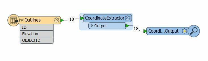
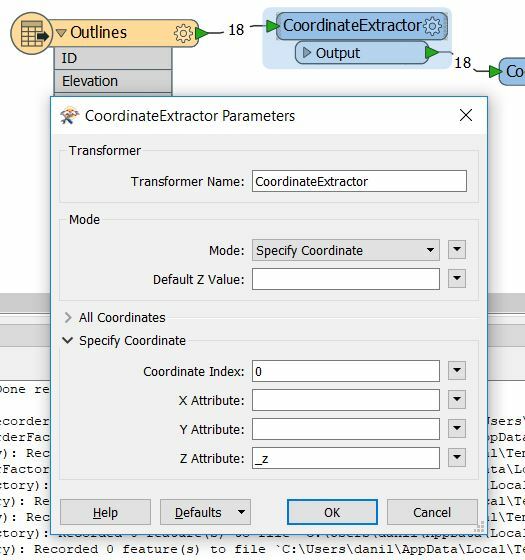
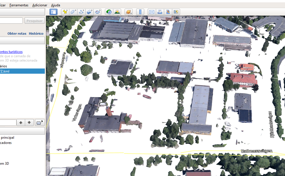
I would like to extract elevation from a KMT or KMZ file from Google Earth! to use them in Autodesk Civil 3D (to DWG file).

Is that possible? I was looking and reading about the Google files inside the FME Knowledge center, but I couldn't find any topics which lead to the answer to my question!

I am very new to FME and this is my first time to use FME. I hope someone can help me with it. Thank you so much for your attention and your help.

Wishing you a wonderful day.

Kindly regards

Salwan Abbosh

Hi @salwan


I believe thatyou can use the transformer CoordinateExtractor:

Parameters:


This transformer generate attributes: x,y and z.


Thanks,

Danilo


Dear Danilo,

Thank you so so much for your response. I will follow your steps and I believe I will be on the right track.

Again very appreciate your help.

Have a nice day

Kindly regards

Salwan Abbosh


Dear Danilo,

Thank you so so much for your response. I will follow your steps and I believe I will be on the right track.

Again very appreciate your help.

Have a nice day

Kindly regards

Salwan Abbosh

Excellent @salman

Have you a nice day too


Dear Danilo,

I am afraid I need some help (my apology for disturbing you). I have done the following:

I have saved a selected area (using polygon) in google earth

I saved the file as KMZ ( the size of the file was very small about 657byets)

I created a new reader, I attached the google file to it with the needed coordinate system to the reader

The file contains NO Z value!

What am willing to realize, is to strip all the Z value from a large area on google earth

But it seems for me unclear how to put this issue together. I am very new for FME and this is my first use

I hope that you have some tips to manage that

Thank you so much for your help


Kindly regards

Salwan

Hi @salwan


Could you share here your kml file to investigate better?

Thanks,

Danilo


My Project XYZ.kmz

My Project XYZ.kml

Dear Danilo,

Thank you so much for your response very very appreciated. Here are the 2 Google Earth KML, KMZ files.

Thank you so much

Salwan


My Project XYZ.kmz

My Project XYZ.kml

Dear Danilo,

Thank you so much for your response very very appreciated. Here are the 2 Google Earth KML, KMZ files.

Thank you so much

Salwan

Hi @salwan

Thanks yours files.

I open the files in FME Data Inspector and there are polygons in 2D.

In GoogleEarth = Do you want to get the Buildings inside your Polygons:?


I believe that is necessary to use the API for Google Earth to integrate with the features from GoogleEarth, using Python libraries - PythonCaller:

https://developers.google.com/earth-engine/


Thanks,

Danilo


Dear Danilo,

Millions of thanks for each moment that you spent on helping me. I don't want the building Z value but the profile of the roads and the existing Ground. I would like to extract the Z value to implement directly to civil 3d DWG drawing to create a surface which I can use to set up my model on it.


Regards,

Salwan


Hi @salwan

No problem! 🙂 Thanks.

In my opinion is necessary to try to do this with API in Google Earth.


Reply