
Hi!

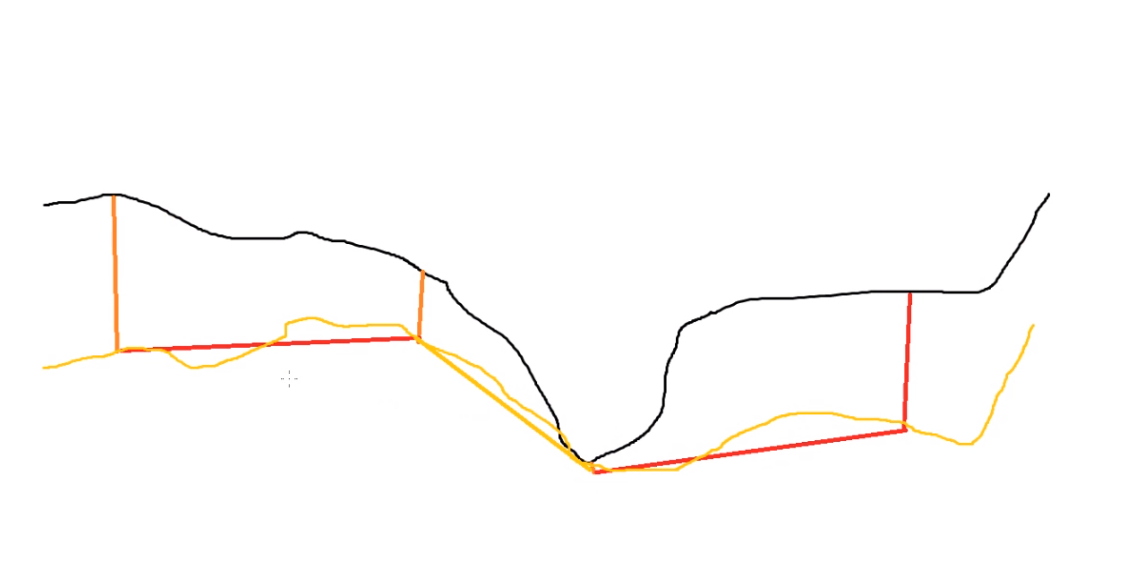
I want to interpolate the terrain model (black line) down in the terrrain. Below shown in orange is 4 points with z value - 10, -5, -1 and -7. To keep the terrain formations similar I want to shift the whole surface/triangle down at certain points. So the new terrain model is not the RED lines, but the yellow lines. Any easy way to shift certain triangle- edges down and have all the connected triangles also "move down"?


Not sure if there is a better way to explain this 🙂

Testing if RubberSheeter does the trick now.


@sigtill: So you have measurments with x,y,z and depth? And you want to generate a TIN-model of the underlying terrain/bedrock, based on these measurments and the existing terrain?


It seems the RubberSheeter does not work with Z-values only X,Y. So I am trying the Custom Transformer from @daveatsafe from 2014 to see if this can work 3DAffineWarper


@sigtill: So you have measurments with x,y,z and depth? And you want to generate a TIN-model of the underlying terrain/bedrock, based on these measurments and the existing terrain?

Yes and no. Since these are very few points I need to interpolate between the points. However I do not want a linear interpolation, I want to "keep the terrain formation". If I create a terrain from the new points only I get the RED lines, but I want to get the yellow lines.


Hi @sigtill,

If you can create a point coverage of the differences in elevation that you want to apply, you can use the SurfaceDraper to do the modification. Set the Existing Elevation parameter to Offset Z.

I used this technique to correct a DEM captured using bad control elevations, and it worked quite well, as long as some of the control points were outside of the DEM. You may need to add zero difference points around the outside of the triangles to properly anchor the adjustment TIN.


Reply