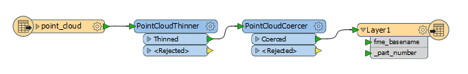
Is it possible to convert an E57 file from a bridge or building to a 3D PDF.
Only have the scan, no photo and everything in a local coordinate system.
This post is closed to further activity.
It may be an old question, an answered question, an implemented idea, or a notification-only post.
Please check post dates before relying on any information in a question or answer.
For follow-up or related questions, please post a new question or idea.
If there is a genuine update to be made, please contact us and request that the post is reopened.
According to the Adobe 3D PDF documentation, it looks like only point, line, and mesh geometries are supported. As mentioned on this Google Thread, it is possible; however, 3D PDF is not very good for displaying lots of points. In order to do this, a good place to start would be to thin the point cloud then coerce the point cloud to points. Note: the points become rasterized by the rendering mode of the viewer application.