Solved

DWG/GPKG Naming Issue


dmerrick
Contributor
Forum|alt.badge.img+1

Hi,

I am exporting a contour featureclass into AutoCAD, Geopackage, and shapefiles using the FeatureWriter transformer by exporting by contour grid.


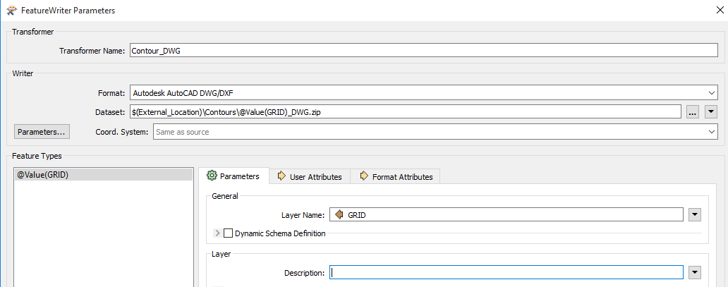
My contour featureclass is in 1km2 grids (255 grids) and is set up in the FeatureWriter to write out

$(External_Location)\\Contours\\@Value(GRID)_DWG.zip where @value(grid) is the contour grid and "_DWG.zip" allows me to easily search/select from within the folder each format (the others being "_SHP.zip" and "_GEO.zip").

The setting under General--> Layer Name: @value(GRID)

For shapefiles the shapefile is just the grid name (ie.50-75.shp within folder 50-75_SHP.zip) but for geopackage and autocad the folder naming schema extends to the layer within despite the general layer name being set to @value(GRID) (ie. 50-75_DWG.dwg within folder 50-75_DWG.zip).


Am I missing a setting?


Best answer by jakemolnar

Do you have an example of the data in its final form, and/or have you tried opening the GeoPackage in Data Inspector? Doing so can show you all of the feature types in your dataset.

One difference between GeoPackage and SHAPE is that GeoPackage can have many tables (feature types) in one dataset, whereas SHAPE only has one.

My suspicion is that you are trying to use a file name as a table name, or that the table name(s) in your GeoPackage might be different from the file name.

Alternatively, maybe the problem is that you are trying to write into a .zip archive? If that's the case, maybe consider writing to a normal file first, and then zipping afterwards?

View original
Did this help you find an answer to your question?

3 replies

jakemolnar
Forum|alt.badge.img
  • Best Answer
  • August 7, 2018

Do you have an example of the data in its final form, and/or have you tried opening the GeoPackage in Data Inspector? Doing so can show you all of the feature types in your dataset.

One difference between GeoPackage and SHAPE is that GeoPackage can have many tables (feature types) in one dataset, whereas SHAPE only has one.

My suspicion is that you are trying to use a file name as a table name, or that the table name(s) in your GeoPackage might be different from the file name.

Alternatively, maybe the problem is that you are trying to write into a .zip archive? If that's the case, maybe consider writing to a normal file first, and then zipping afterwards?


dmerrick
Contributor
Forum|alt.badge.img+1
  • Author
  • Contributor
  • August 8, 2018
@jakemolnar

Your suspicions are correct regarding the file name as a table name. Once changed the data became recognizable to data inspector.


Thanks!

jakemolnar
Forum|alt.badge.img
dmerrick wrote:
@jakemolnar

Your suspicions are correct regarding the file name as a table name. Once changed the data became recognizable to data inspector.


Thanks!
No problem, glad I could help!


Cookie policy

We use cookies to enhance and personalize your experience. If you accept you agree to our full cookie policy. Learn more about our cookies.

 
Cookie settings