Question

Classified Point cloud vegetations to polygons

  • June 15, 2026
  • 1 reply
  • 21 views

a.sabzevari69
Contributor
Forum|alt.badge.img+3

Hi,

I have classified LiDAR data containing low, medium, and high vegetation points, and I need to convert the vegetation point clouds into canopy polygons.

What is the recommended FME workflow for this?

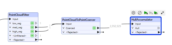
I have tested the HullAccumulator transformer, and the results look reasonably good and follow the vegetation points quite well. However, I’m not sure whether this is the most appropriate or reliable method for producing canopy polygons, especially for canopy coverage calculations.

Would a raster-based workflow be more suitable, or is HullAccumulator commonly used for this purpose?


Thanks.


1 reply

j.botterill
Influencer
Forum|alt.badge.img+58
  • Influencer
  • June 15, 2026

HullAccumulator is useful for quick, visual envelopes. It produces convex or near-convex geometry so can overestimate canopy extent (fills gaps). I assume your LIDAR point density is fair even, not clustered.

A raster based canopy extraction process might handle irregular point clouds better to produce a continous surface and allow for height filtering etc.

  1. PointCloudFilter for your classes you want included
  2. PointCloudRasterizers for Z and statistic = Max for a height model or Count for presence/absence of canopy
  3. RasterExpressionEvaluator where you use the @value(raster) > a threshold… or simply count > X giving you canopy 1 or non-canopy 0
  4. RasterToPolygonCoercer
  5. Post processing might include GeometryFilter, Dissolver (to merge canopy areas?) or Generalizer etc