Hello everyone, 


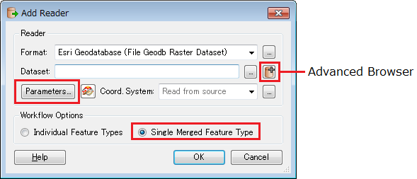
Would appreciate if anyone could give me a hint if this is possible to process multiple raster datasets within file geodatabase as single merged reader? I need to convert one gdb raster datasets into set of tiles within another gdb raster catalog and struggling with reading all of the input files at once.


Is this possible? 


PS. This is my first post here so I hope I didn't break any posting rules. 


Cheers, Kim
Hi Kim,


When adding the "File Geodb Raster Dataset" reader:


Select "Single Merged Feature Type" option in "Add Reader" dialog box,


Click "Parameters" button to open parameter settings dialog box, and select all the required rasters (tables) in "Table List".


You can also select 2 or more gdb folders using Advanced Browser.


Takashi
Dear Takashi-san,


Many thanks for your response!


This is exactly the way I tried to read my features. The only thing I missed is selecting all the tables in the gdb (I just left it blank and thought it meant 'all features to read'). 


Thanks a lot again, the question is well answered. 


Best Regards,


Kim

Reply