Question

Geographic orientation

  • April 28, 2026
  • 4 replies
  • 106 views

aymeric17
Contributor
Forum|alt.badge.img+3

Hello,


In FME Form, I am trying to generate a line from 3 parameters: 

  • lon/lat (WGS 84)
  • length
  • geographic orientation (from geographic north, in degrees)

I have tried several ways to build this line (2DDirectionExtender, VertexCreator + Offsetter (tested polar coordinates or spherical coordinates), VertexCreator + Rotator)

Always the same result, when I measure the angle from geographic north, there is a difference for instance, with my input:

  • lon/lat : -4.49027778, 48.02000000
  • length : 0.002
  • orientation : 100.478°

In both methods, FME gives me this result:

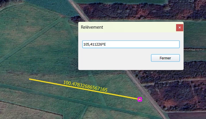
When I calculate the bearing from start point to generated end point, it gives me the same result 105.411° (same with online bearing calculators using coords)

Any idea on what could be wrong?


Thank you

4 replies

hkingsbury
Celebrity
Forum|alt.badge.img+71
  • Celebrity
  • April 28, 2026

I suspect this is probably a coordinate system issue…. ​@redgeographics My mind first jumped to you for a solution


redgeographics
VIP
Forum|alt.badge.img+62

Most likely coordinate system, yes. But I didn't pay close enough attention in geodesy classes 😅 (and I'm on a little holiday at the moment).


I would also like to point out that since you specify the length in WGS84 degrees and the length of a degree differs based on your position on earth and the direction you're measuring in, your method may introduce errors (can't get my head around those at the moment)


aymeric17
Contributor
Forum|alt.badge.img+3
  • Author
  • Contributor
  • June 2, 2026

Thank you for your help.

I used the length in WGS84 degrees to simplify the use case for the test. The exact length isn’t important at this stage since I reproject to a local projection when I need accurate measurements 😊 The length is therefore correct — only the rotation is incorrect.

I’m still stuck on this issue. Any other idea? 


crystalwang
Safer
Forum|alt.badge.img+22

Hi ​@aymeric17,

Thank you for posting your question on the FME Community!

Although I am a bit rusty with coordinate systems, would it make a difference if you reprojected to a projected coordinate system (eg. EPSG:32630) before building the line? Then after, reprojecting to a geographic coordinate system such as WGS84 if needed.