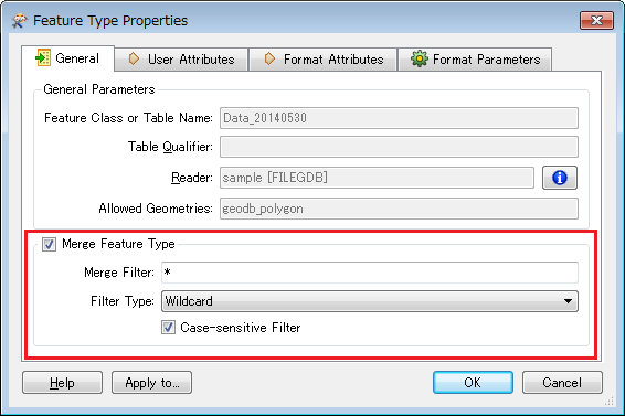
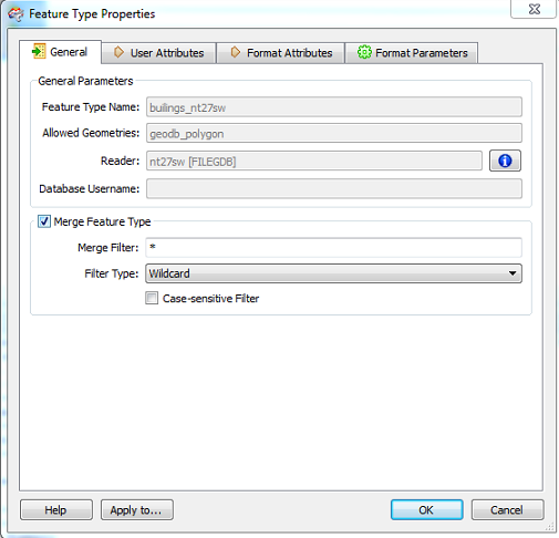
Hi All   I have a workbench that reads from an ESRI FGDB and writes to AutoCAD DWG. The FILE GDB only contains one feature (lots of polygons) & I need to batch process this many times but each time the "FEATURE TYPE NAME" is slightly different - e.g. -   Buildings_nt27sw   or  Buildings_sw34nw   I can only seem to set the feature type name as fixed and not to dynamicaly alter each time a new FGDB gets called. I don't appear to be able to link the feature type name to a user parameter that I can pass in from the command line or set the feature type name to be referenced from a wildcard - e.g. *Buildings*   Any help much appreciated   Thanks,   Mike 
Hi Mike, have you tried the Merge Feature Type option for the reader feature type?


Takashi

Hi Takashi


I have tried this method. If I have a "SourceDataset" with feature type name - "buildings_nt27se" it works fine. If I then try again with a different FGDB that has feature type name "buildings_nt26nw.gb" the log file says no matching table:


Geodatabase Error (-2147220655): The table was not found.


Could not open File Geodatabase table `builings_nt27sw'


?
Sorry that should be feature type name "buildings_nt26nw"
Since the source GDB dataset contains only one feature type, you don't need to specify any feature type name to the reader.


Hi Takashi


I can't add a FGDB reader without the "feature type name" being added automatically - or alternatively the "feature type name" cannot be removed from the existing reader as it is grayed out and un-editable.


Mike


Sounds strange. I believe that setting dataset (*.gdb) is essential but selecting feature type (table) names can be omitted, when you add GDB reader to the workspace.


All feature types would be added to the workspace if you didn't select feature types. In this case, however, since the dataset has only one feature type, you don't need to select it.
If I add the FGDB and leave the table list selection blank - it always populates the "Feature Type Name" box with the single layers name.
There is no problem since you have checked the "Merge Feature Type" option. The grayed "Feature Type Name" box will not be used, you don't need to mind it.
If that is the case then why when I change the source FGDB do I get the following? 


Geodatabase Error (-2147220655): The table was not found.


Could not open File Geodatabase table `builings_nt27sw'


It is essential still trying to find the nt27sw table
Make sure these are all blank.


"Feature Types to Read" parameter


"--FEATURE_TYPES" command line option
The parameter was populated with 'builings_nt27sw' but even after removing I still get the same error:


Geodatabase Error (-2147220655): The table was not found.


Could not open File Geodatabase table `builings_nt27sw'
How was the command line option?
Awesome! That finally solved things. Running from the command-line:


fme copy_2.fmw  --SourceDataset nt26nw.gdb --DestDataset new_test_5.dwg --FeatureType buildings_nt26nw  -LOG_FILENAME test.log


I can now write up a bash script that can loop through all the values.


Thanks so much for your help, and being patient Takashi!!


Mike


Good to hear you accomplished the goal :)


Additional comment.


If it is guaranteed that the source dataset always contains just one feature class, it's not essential to specify the feature type name through the command line. You can set blank to the option like this, or don't need to write the option itself if the default value of the parameter has been set to blank.


--FeatureType ""

Reply