Question

How to configure alternate ArcGIS Online background maps

  • 29 October 2020
  • 4 replies
  • 111 views

My local Esri reseller in The Netherlands makes available specific basemaps for its dutch users. Their extent, content and coordinate system have been customized as such. But, more importantly, they are supplied from a different URL than the world basemaps by Esri Inc.

The latter are hosted from services.arcgis.com, but the ones I would like to use as a background map are hosted from services.arcgis.nl.

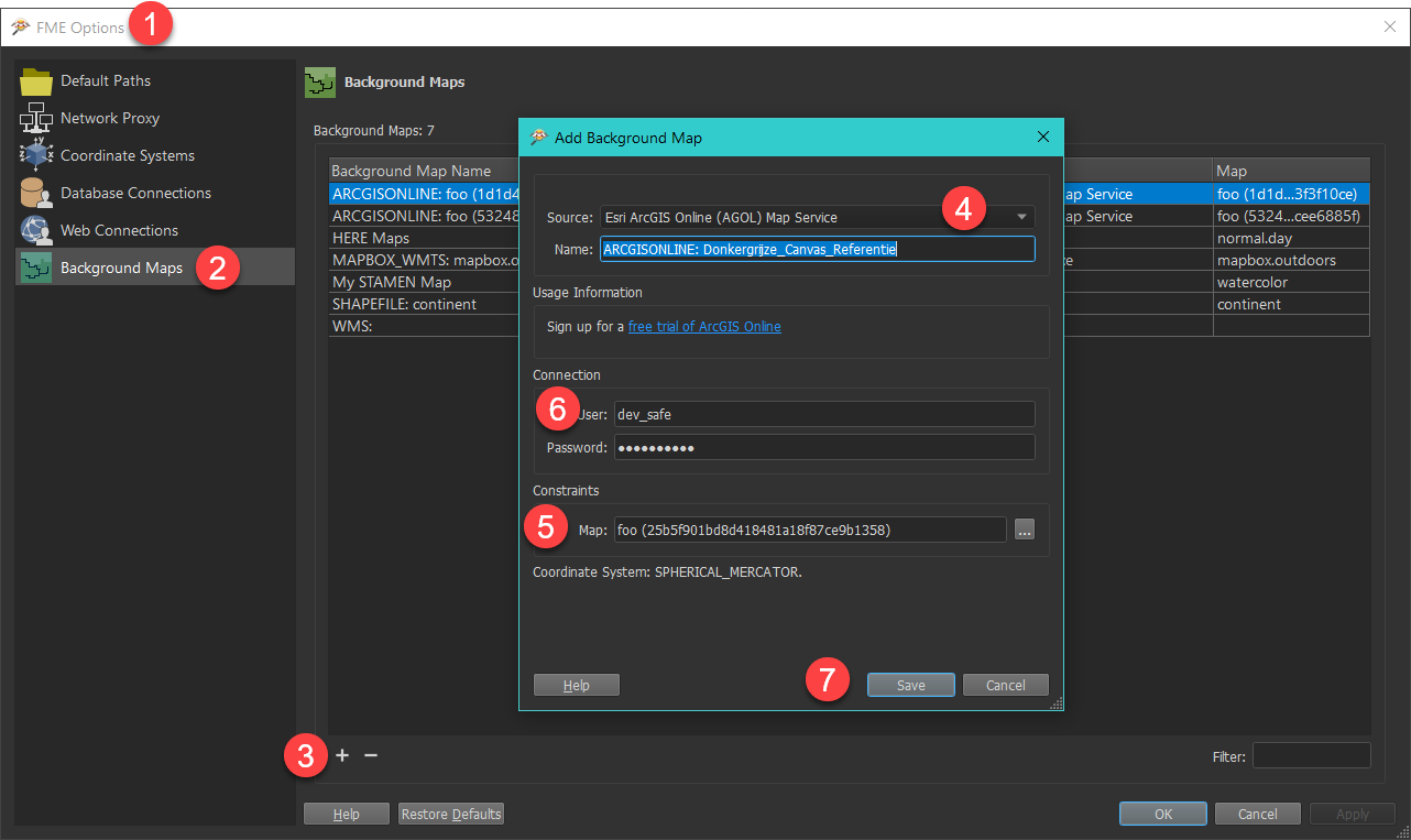
The Background Map dialog allows me to either configure a standard web map service, like ArcGIS Online (in this case: arcgis.com). The best choice here, I should think, is "Others".

But then the dialog acts like a Reader configuration and I can only choose an ArcGIS feature service, which is not the right one for the basemaps.

So, I tried the option "Esri ArcGIS Online (AGOL) Map Service" for the source, and filling in the URL in the "Map List" textbox:

https://services.arcgisonline.nl/arcgis/rest/services/Basiskaarten

But then I get stuck because credentials are asked (for maps which are public), and valid credentials are not accepted.


So how do I set this up? Your help is greatly appreciated.


Kind regards,


Ferdinand.

Hi @ferdinandbogman​ 

Unfortunately, I'm not certain you will be able to use the custom background maps within FME 2020.


However, it appears that the map services are offered as a web map tile service (WMTS). Our development team is currently actively working on adding support for WMTS and plans on exposing it as a Background Maps format. Once support has been added, then it may be possible to use the background maps at the link you have provided.


I will update this post once support for the WMTS has been added in the Data Inspector.


Hello Debbi,


Thanks for your reply. To make things clear, I am not looking for a possibility to use WMTS. The services I want to use are perhaps also offered in that format. So it might be an alternative, once it is available.


But their primary format is the ArcGIS (cached) map service, just like the ArcGIS.com services.

So my question narrows down to finding a way to use an alternate URL which behaves just like the standard ArcGIS.com URL. That includes not having to authenticate.


Hello Debbi,


Thanks for your reply. To make things clear, I am not looking for a possibility to use WMTS. The services I want to use are perhaps also offered in that format. So it might be an alternative, once it is available. 


But their primary format is the ArcGIS (cached) map service, just like the ArcGIS.com services. 

So my question narrows down to finding a way to use an alternate URL which behaves just like the standard ArcGIS.com URL. That includes not having to authenticate.


Hi @ferdinandbogman​ , 

The ArcGIS Online background maps that are used in FME Data Inspector are primarily Web Map

Steps to create ArcGIS Online Background maps 

foo (25b5f901bd8d418481a18f87ce9b1358)

Screenshot below ArcGISOnlineBackgroundMaps NOTE:

I notice that you feature service is using EPSG:28992 which may not work

Our ArcGIS Online background map shares code with the other Python-based background map formats. They all assume a system that has min/max zoom levels and XYZ integers that uniquely identify a single map tile and they’re all Spherical Mercator (AKA Web Mercator).

Thank you rahulsharma,


The procedure you describe worked, after I discovered that I forgot to place the brackets around the item id ;-).


But, as you warned me, the coordinate system is messing things up. The services are only available in EPSG 28992 since they are meant for underlaying dutch data. So even in Spherical Mercator I can't properly use it to view my data.

Neither are they served as WMTS, so I seem to be on a dead end street here.


Thanks for spending time on this, I will consider suggesting this as an idea: the ability to use other coordinate systems with ArcGIS Online layers. 


Regards,


Ferdinand


Reply