Solved

Vector to Raster conversion

  • January 24, 2018
  • 11 replies
  • 140 views

Forum|alt.badge.img+1

Hi,

I have a point Shapefile that I would like to recreate in raster, specifically, ESRI Ascii Grid format.

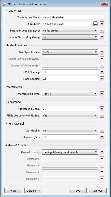
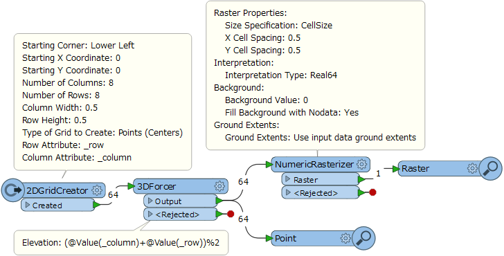
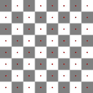
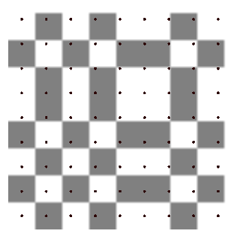
However I am having issues in that when I use the 'NumericRasterizer', some of the resultant cells in the raster are up to 0.25m away from the original location of the points. Is there any way that I can set the rasterizer (or use a different transformer) to force the resultant cells to be overlaid exactly on the original points (ie: points will lay in the centre of the cell)?

Thanks

Best answer by takashi

Hi @aquamarine, I think the NumericRasterizer with your setting creates desired raster if the original points form a grid with spacing 0.5m x 0.5m. How did you confirm that the center of cells in the resulting raster have been moved 0.25m from the original points?

This post is closed to further activity.
It may be an old question, an answered question, an implemented idea, or a notification-only post.
Please check post dates before relying on any information in a question or answer.
For follow-up or related questions, please post a new question or idea.
If there is a genuine update to be made, please contact us and request that the post is reopened.

11 replies

erik_jan
Contributor
Forum|alt.badge.img+22
  • Contributor
  • 2179 replies
  • January 24, 2018

Have you looked at the MapnikRasterizer?

I find that one easy to use.


Forum|alt.badge.img+1
  • Author
  • 271 replies
  • January 24, 2018

Have you looked at the MapnikRasterizer?

I find that one easy to use.

Thanks @erik_jan


I tried the MapnikRasterizer but I am getting the following error:


REJECTING BELOW FEATURE: Polygon feature must have at least 4 coordinates...rejecting


I am importing a point shapefile not a polygon file. Is there a way to set it so that it knows I am importing point data.


erik_jan
Contributor
Forum|alt.badge.img+22
  • Contributor
  • 2179 replies
  • January 24, 2018
Thanks @erik_jan


I tried the MapnikRasterizer but I am getting the following error:


REJECTING BELOW FEATURE: Polygon feature must have at least 4 coordinates...rejecting


I am importing a point shapefile not a polygon file. Is there a way to set it so that it knows I am importing point data.


Per imported layer in the MapnikRasterizer you can set the type of features (geometry) and the style options.


Have a look at this document: MapnikRasterizer


david_r
Celebrity
  • 8394 replies
  • January 24, 2018

Can you show us how you've configured the NumericRasterizer?


Forum|alt.badge.img+1
  • Author
  • 271 replies
  • January 24, 2018

Can you show us how you've configured the NumericRasterizer?

Hi @david_r


These are the settings I used!


david_r
Celebrity
  • 8394 replies
  • January 24, 2018
Hi @david_r


These are the settings I used!


This is what the transformer is doing, based on your configuration:


- Calculate the extent (bounding box) of all your points


- Divide the totalt extent into a grid of 0.5 x 0.5 meter large cells


- If a point is inside a cell, the cell gets the value from the point


So unless your points are all perfectly lined up in accordance with the grid, you'll often get these effects.


One way to mitigate this problem could be to set a user-defined ground extent in the NumericRasterizer and do a slight offset compared to your point extents, e.g. half a cell off (-0.25).

takashi
Celebrity
  • 7843 replies
  • Best Answer
  • January 24, 2018

Hi @aquamarine, I think the NumericRasterizer with your setting creates desired raster if the original points form a grid with spacing 0.5m x 0.5m. How did you confirm that the center of cells in the resulting raster have been moved 0.25m from the original points?


takashi
Celebrity
  • 7843 replies
  • January 25, 2018

Hi @aquamarine, I think the NumericRasterizer with your setting creates desired raster if the original points form a grid with spacing 0.5m x 0.5m. How did you confirm that the center of cells in the resulting raster have been moved 0.25m from the original points?

I checked it with this workspace. numericrasterizer-experiment.fmw (FME 2017.1.2.1)


Result. Looks the center of cells in the resulting raster match the original points (red).


david_r
Celebrity
  • 8394 replies
  • January 25, 2018

A possible source of the issue could be that the raster cell size isn't exactly the same as the point spacing. Here's what it looks like if we use Takashi's example and set a raster cell size of 0.55 while retaining a point spacing of 0.5:

Notice how the points "drift" compared to the raster cells, eventually crossing into the neighboring cell.


takashi
Celebrity
  • 7843 replies
  • January 25, 2018

A possible source of the issue could be that the raster cell size isn't exactly the same as the point spacing. Here's what it looks like if we use Takashi's example and set a raster cell size of 0.55 while retaining a point spacing of 0.5:

Notice how the points "drift" compared to the raster cells, eventually crossing into the neighboring cell.

Yes, it's a possible situation. Also if the original points didn't form a grid with equi-spacing, naturally cell centers won't match the original points.


Another thought. Once set the cell origin to (0, 0) and then transform the raster into grid points with the RasterCellCorecer, the resulting points match left-bottom corners of the cells. It seems that FME reads an Esri ASCII Grid raster with cell origin (0, 0), so I think this is also a possible situation.


Anyway, let's wait for @aquamarine's response.


Forum|alt.badge.img+1
  • Author
  • 271 replies
  • January 29, 2018

Hi @aquamarine, I think the NumericRasterizer with your setting creates desired raster if the original points form a grid with spacing 0.5m x 0.5m. How did you confirm that the center of cells in the resulting raster have been moved 0.25m from the original points?

Thanks @takashi


I realize now that the issue was that my original point shapefile was not evenly gridded at 0.5m intervals and that's why I wasn't getting the NumericRasterizer to work. I will need to recreate the point shapefile with 0.5m intervals.