I'm trying to transform Aircom Enterprise Map/Data Asset file to ESRI Shapefile

I get empty Shapefile

As input I've : index.txt, menu.txt and two binary files: g2 and g3 .

I can open my files in FME data inspector .

I tried to transform Asset files to 2D Shapefile or 2D with measurements, as result both transformations skipped the 2 features : g2 and g3

Please help , log file attached

Hello @t0ren

Could you share us your Workspace template file?

Thanks,

Danilo


Hello @t0ren

Could you share us your Workspace template file?

Thanks,

Danilo

Hello @danilo_fme


I used "FME Data inspector" and "FME Quick Translator" . I used FME defaults during installation . What the location of template file ? Sorry for newbie question


I attached rest of my files


g3.zip


index.txt


menu.txt


g4.zip


Thanks for help


Hello @danilo_fme


I used "FME Data inspector" and "FME Quick Translator" . I used FME defaults during installation . What the location of template file ? Sorry for newbie question


I attached rest of my files


g3.zip


index.txt


menu.txt


g4.zip


Thanks for help


Hi @t0ren


Thanks your examples. What extension format are the files g3.zip and g4.zip?


I opened and extract them, but they are coming without format.


Thanks,


Danilo


@danilo_fme Thanks Danilo . No extension these are binary files, but I guess Quick Data inspector can see the content of these files


@danilo_fme Thanks Danilo . No extension these are binary files, but I guess Quick Data inspector can see the content of these files


Hi @t0ren, When reading Aircom data, the index.txt file is the only file you need to add to the reader as the Dataset. and this will bring the data contained in the other files in the same subfolder. (you can read more about how FME read Aircom data in our Documentation)

However, We tested reading your Aircom data, and discovered that g3 and g4 are both 2000 x 2000 rasters whose values are all 255 (no data).

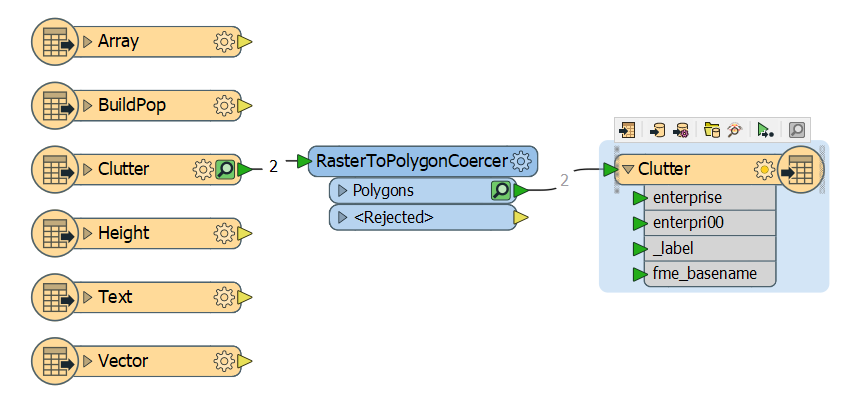
Since the raster doesn't contain any meaningful data, do you just want to extract the boundaries of these two raster features into shapefile polygons? If so, you can use a RasterToPolygonCoercer to convert the raster feature into polygon, before writing out to shapefile. The workspace would look something like this:

Hope this helps a bit. Please let me know if you have more questions.

Thank you for replay ! Actually I'd like to export Clutter grid to shape file


Hi @t0ren, When reading Aircom data, the index.txt file is the only file you need to add to the reader as the Dataset. and this will bring the data contained in the other files in the same subfolder. (you can read more about how FME read Aircom data in our Documentation)

However, We tested reading your Aircom data, and discovered that g3 and g4 are both 2000 x 2000 rasters whose values are all 255 (no data).

Since the raster doesn't contain any meaningful data, do you just want to extract the boundaries of these two raster features into shapefile polygons? If so, you can use a RasterToPolygonCoercer to convert the raster feature into polygon, before writing out to shapefile. The workspace would look something like this:

Hope this helps a bit. Please let me know if you have more questions.


I'd like to export Clutter grid to shapefile with saving bin definition of each of object listed in menu file : 1) skyscrapers 2) high-density urban 3) medium-density uban/suburban 4) low-density residential/suburban/village 5) heavy industrial areas6 commercial and services 7) transportation infrastructure 😎 forest 9) low-density wooded areas 10) low vegetation 11) open/barren land 12) water bodies 13) open in urban 255) no data


Another issue (sorry for newbie question) I don't have _label attribute on right side Clutter


Thanks a lot !
Hi @t0ren, I'll try to address the 3 questions:


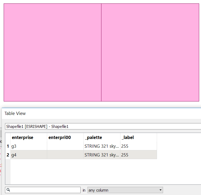
  1. By Clutter grid, do you mean something like the image below? The polygons represent the boundary of g3 and g4 respectively.


  2. After inspecting the data in FME Data Inspector, I noticed that the definition information is stored in palette. so we can use a RasterPaletteExtractor to extract the definition info into a multi-line attribute, before RasterToPolygonCoercer. However, Shapefile doesn't accept any attribute value that's longer than 254 characters. And unfortunately the list of definition for this dataset exceeds that limit. To work around this shapefile limitation, In the demo workspace attached here, I used AttributeSplitter and ListElementExtractor to split the long attribute into shorter individual attributes, each containing only one definition. (Detailed explanation is in the workspace annotation).


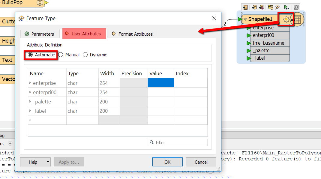
  3. To get the new attributes showing (such as _label and _palette in the screenshot above), you need to change the writer (under User Attributes tab) to Automatic mode. Note: After populating all the attributes using the Automatic mode, you can always switch back to Manual, and remove the unwanted attributes as well:


enterprise2esrishape.fmw is the workspace I created as a demonstration. Hope this helps

Reply