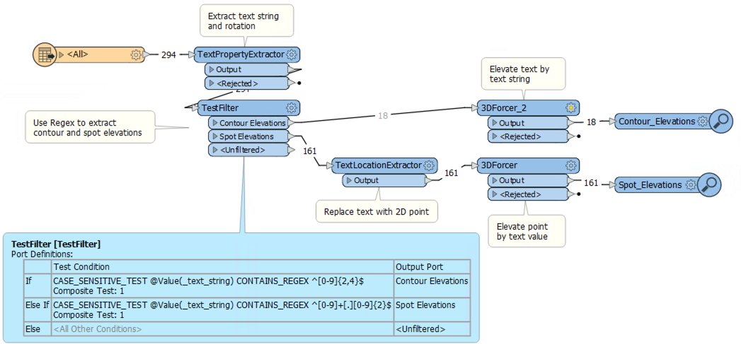
A PDF file contains points located using TEXT elements that indicate the Z coordinate for each point.
My question is this: How can I obtain a file (WRITER) in DWG format that contains a cloud of points in coordinates X, Y, Z, from the X and Y coordinates of the insertion point of the text and the Z coordinate obtained from reading the label of that text?
Another feasible option would be to obtain a CSV file of numbered points (writer)
A second question, which is a continuation of the first:
A flat map is available in 2D DWG format, which contains contour lines. Contour lines are labeled dimensions (Z-coordinate) every few intervals.
How could we obtain a mathematical model (mesh) from the given contour lines inferred and interpreted as lines of rupture with its dimension (Z coordinate) obtained from the value of the text belonging to the contour of a 2D flat file?
The attached file in DWG format, has been obtained by filtering a PDF file obtaining as a result the texts. Now what interests us is to execute a second filtering to discard the texts that contain ALPHA characters and stay only with those that meet the following attributes:
1º.- That only contain numbers.
2º.- That they are horizontal, that is, that they are not inclined.
3º.- That only contain two decimal places and separator ","
4º.- That do not contain special characters.
The objective is to obtain a list of points whose X and Y coordinates are obtained from the insertion point of the text with a specific format and the Z coordinate is obtained from the value of the text itself, whose format is in all cases the following, for example (attached file)


