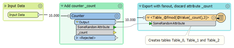
We have a Mapinfo file with customers and we're using this stupid third party geocoder (for now hopefully changing) and we're pretty sure it's having an issue because of the size of the table we're sending it. I was thinking maybe I could get around it by having FME split the table into 3 equal tables and then geocoding them and then combining them back together. Does anyone know of a way to do this? There's no real column info that I could export based on anything it would have to be after X rows or something similar to that. Thanks so much! 😀

Question
Split Mapinfo Table into 3 equal sizes.


Login to the community
No account yet? Create an account
An FME Account is required to contribute
LoginEnter your E-mail address. We'll send you an e-mail with instructions to reset your password.