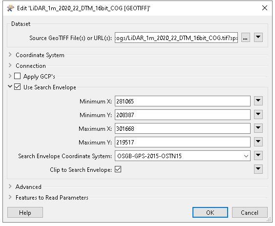
Hello @tomcolley, yes, FME should be capable of consuming COG datasets. If you specify the extents, it should only return the data you ask for. I have a few questions for you, if you don't mind:
- What version of FME are you using?
- Are you reading from a file or URL?
- Are you using a custom coordinate system in the Seach Envelope?
Fairly curious, if you were to reproject data to a common projection, does the error persist (LL84, for example)? I wasn't able to reproduce the error, but I used a standard CS. If you're unable to share data here, consider submitting a support case so we can take a closer look. Happy to help, Kailin
Hi @kailinatsafe , thanks for your reply.
- It's FME 2022.1
- I read from a URL (https://dmwproductionblob.blob.core.windows.net/cogs/LiDAR_1m_2020_22_DSM_16bit_COG.tif) originally but have just downloaded and tried it as a local file with the same result.
- The coordinate system is OSGB-GPS-2015-OSTN15. Originally I had it set to EPSG:27700 which gave this warning: "NOT changing coordinate system of reader identified by keyword `GEOTIFF_1' from `EPSG:27700' to `OSGB-GPS-2015-OSTN15' -- mapping file setting of `EPSG:27700' overrides coordinate system `OSGB-GPS-2015-OSTN15' read from file".
I don't have access to data in a more common projection but it would be really good to see if you get the same issue with my file.
Thanks again for your help
Tom
Hello @tomcolley, thanks for your patience. By the way, you're using a standard CS, sorry if I confused you there! I've filed an issue with our development team as FMEENGINE-76657. I've made a note to update this thread when a fix is available. Hope this helps! Kailin.
Hello @tomcolley, I am pleased to announce FMEENGINE-76657 has been resolved in FME 2023.0 b23288+, you can find this version on the Downloads Page. Happy to help, Kailin.
That's great, thanks for letting me know I'll give it a go and let you know how I get on.