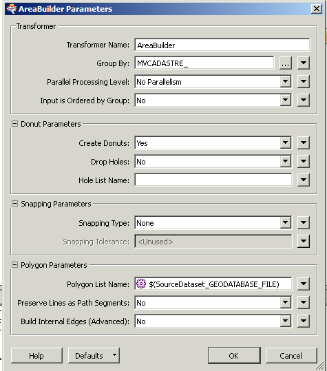
Hi @ldengler, in FME 2016.1+, the AreaBuilder preserves attributes of a representative line by default, and also it can generate a list which contains attributes of all lines optionally. See the "Attribute Accumulation" parameters group. Doesn't these functionality satisfy your requirement?
Hi @takashi, thanks for your reply. However I forgot to specify that I am using FME 2014, running off a Citrix Server so I do not have options to upgrade. So unfortunately I do need to find a way to manually preserve them.
the ability to generate a list, as mentioned by takashi is also possible in fme 2014.
Hope this helps
Hi @itay,
I could be missing something but I really don't understand about how to create the relevant list. These are the parameters I used for my last run. The polygons came through without attributes. I had also previously attempted giving the list an arbitrary name, as per suggestions in the above links.
I'm currently reading through the documentation on FME parameters, to try to figure out how to better define a list. Still don't entirely understand the lingo however, any further thoughts would be appreciated. Thanks!
You have set a user parameter to the list name parameter. If the parameter value is not set, naturally the list will not be created. Even if the parameter value has been set, it may not be reflected on the Workbench GUI.
Hi @ldengler,
Yes using a parameter might not work, you can simply type 'MyList' in the teansformer parameter.
Another thing to mention is that list elements are only visible in the feature information window of the data inspector and not in the table view.
This article - https://knowledge.safe.com/articles/33912/point-in-polygon-calculations-with-the-pointonarea.html - may help you understand lists a bit better. It's a point-in-polygon example where there can be multiple points per polygon.
Basically a list is an attribute with multiple values. Few formats will accept such a thing, so you need to do something with it. For example, use a ListConcatenator transformer to merge all the list values into a single attribute.
Hope this helps.
Thank you everyone for your suggestions! I got sidetracked with another project the last few days so have not had a chance to test them out yet. However it looks like I should be able to resolve this next week!
Reviving an old thread here, finally had a chance to pick this back up again!
Thanks to the above suggestions, I was able to get the attributes and geometry to come through to the FME Data Inspector. However, I am still having trouble getting the attributes to save in my output geodatabase. I can see the attributes in the Inspector, but the .gdb saves geometry only. I can preserve attributes if I manually save features from the Inspector, but this means I am saving 60+ features individually as individual feature classes then later merging them back together...
Is there some trick for saving feature classes from FME to Arc format?
Have you defined any user attributes on the writer feature type?