Solved

Merge features from CAD to GIS in the same workflow.


Forum|alt.badge.img

Hello,

I have a cad file that contains lines, points, poligons and surfaces and i want to filter the geometry and in the same time to merge all the line on a single feature class, the the poligons , points, etc . I haven't found any transformers that can help me with this.

Can you tell me if there is any transformer like "Merge" function in ArcMap? I was using a model builder to merge the features after the translation. Also the same model was used to calculate fields or to add a new one. Is this possible in FME?

Best answer by alexandrus

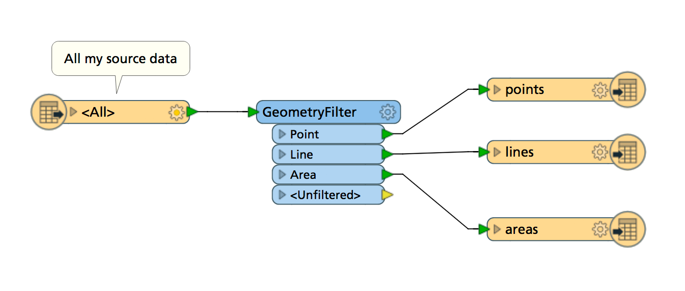
thanks for the screen shot. After the GeometryFilter, do you have 3 different writers? is the same geodatabase? or is a different one for each geometry? and inside each writer are the gemetries merged?

View original

8 replies

redgeographics
Celebrity
Forum|alt.badge.img+45

You can use the LineCombiner to merge lines (that means that if 2 lines are touching they will be combined into a single line), the Dissolver does the same thing but for touching polygons. For points you could use an Aggregator.

Unless you want to merge entire featureclasses into a single one. That can be done by simply drawing 2 or more connections into the same writer.


Forum|alt.badge.img
  • Author
  • December 12, 2017

My line for example are not touchuing , but i want to have them unde a single layer:

for example , during the translation i want to have all lines merged in a single layer, poligons as well, points...etc. I'm looking into having the same function as in ArcMap , but based on geometry.


redgeographics
Celebrity
Forum|alt.badge.img+45
alexandrus wrote:

My line for example are not touchuing , but i want to have them unde a single layer:

for example , during the translation i want to have all lines merged in a single layer, poligons as well, points...etc. I'm looking into having the same function as in ArcMap , but based on geometry.

If they're originally on the same layer you can use the GeometryFilter to sort them out and then, as I said, simply write them all to separate feature types.


Forum|alt.badge.img
  • Author
  • Best Answer
  • December 12, 2017

thanks for the screen shot. After the GeometryFilter, do you have 3 different writers? is the same geodatabase? or is a different one for each geometry? and inside each writer are the gemetries merged?


redgeographics
Celebrity
Forum|alt.badge.img+45
alexandrus wrote:

thanks for the screen shot. After the GeometryFilter, do you have 3 different writers? is the same geodatabase? or is a different one for each geometry? and inside each writer are the gemetries merged?

It can either be 3 feature types in 1 writer, or 3 writers with 1 feature type each (or any other possible combination), whichever you want.


Inside each writer, the geometries are merged, or not, depending on what you mean by "merged".


If you want touching lines or polygons to be combined into single features then no, these are not merged. You'll need a LineCombiner or Dissolver for that.


If you just want them to be grouped in to a single layer then yes, this is what you want.


Forum|alt.badge.img
  • Author
  • December 12, 2017
alexandrus wrote:

thanks for the screen shot. After the GeometryFilter, do you have 3 different writers? is the same geodatabase? or is a different one for each geometry? and inside each writer are the gemetries merged?


It worked . Thanks for the tip. Now, i don't know if you can help me, but for example is it possible to add fields and to calculate them based on the attributes from the cad file. Ex: i want to add a field for the new merged poligons and the to calculate it with an expression (to add inside the fields just the characters from 10-15)


redgeographics
Celebrity
Forum|alt.badge.img+45
alexandrus wrote:


It worked . Thanks for the tip. Now, i don't know if you can help me, but for example is it possible to add fields and to calculate them based on the attributes from the cad file. Ex: i want to add a field for the new merged poligons and the to calculate it with an expression (to add inside the fields just the characters from 10-15)


Yes, it depends a bit on what exactly you want to calculate, but the AttributeManager would be the best place to start.


Do keep in mind that if you're calculating attributes you'll need to add them to the output feature types as well (if you want them to be present in the output files)


Forum|alt.badge.img
  • Author
  • December 12, 2017
redgeographics wrote:
Yes, it depends a bit on what exactly you want to calculate, but the AttributeManager would be the best place to start.


Do keep in mind that if you're calculating attributes you'll need to add them to the output feature types as well (if you want them to be present in the output files)


Ok. i will try and see how it works.


Thanks for the help


Reply


Cookie policy

We use cookies to enhance and personalize your experience. If you accept you agree to our full cookie policy. Learn more about our cookies.

 
Cookie settings