Hi,


I saw that in 2011 that it was mentioned that many folks would like for the Joiner transformer to be able to use data from a File Geodatabase.  It was said at the time that it is on the list of things to accomplish.


I am currently running FME 2012 SP4 and will be upgrading in the forseeable future; however, I'd like to know if this functionality has been implimented yet.


I am attempting to do what I need using the FeatureMerger, but would like to see if there is an appreciable difference in time as well between using FM or Joiner.  This is especially true since I will be needing to run a Tester to run the Joiner using Oracle data to catch what is not available in the File Geodatabase.


Thanks,


Lorinda
Hi Lorinda,


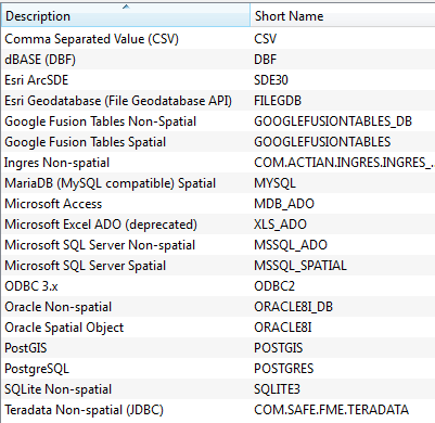
In the latest release version (FME 2013 SP4 Build 13547), I could select "Esri Geodatabase (File Geodatabase API)" as Reader Format parameter of the Joiner. To get the exact information, contact your reseller or Safe.


Takashi
Hi,


here is the complete list of supported formats for the Joiner in FME 2013 SP4:


Except for the addition of two Amazon entries, the list look unchanged in FME 2014 Beta.


Since you're touching on performance, you might also benefit from looking at the InlineQuerier. It can be very efficient if you're joining several datasets. In other words, if you have several chained Joiners you can probably replace them both with a single InlineQuerier.


If you're using the Joiner, make sure that you fully utilise the prefetch query (see the help), it can make a huge difference in performance if the joined dataset is of moderate size and FME can fit it all into memory.


David
Hi,


Some more information about the FeatureMerger vs the Joiner, maybe a bit outdated but can still be useful.


Itay
Thanks for the update, now another issue.  Have downloaded the 2013 SP4 and was able to use the file geodatabase on the joiner.  Now I've got another issue which likely should be moved to another question, but going to put it here first.


I'm using raw data of the parcel_polygons and attempting to aggregate the ones that are non-contiguous but have the same parcel id.  I thought that the transformer/function to use was Aggregate, however when I use it (or not) I keep getting the following message


"INFORM|Transaction #11 was successfully committed

2013-11-12 18:39:17| 456.8| 0.8|ERROR |Cannot write a non-area feature to an area feature class

2013-11-12 18:39:17| 456.8| 0.0|STATS |Storing feature(s) to FME feature store file `J:\\Fme/fgdb2oracle_mergeparceldata_log.ffs'

2013-11-12 18:39:17| 456.8| 0.0|ERROR |+++++++++++++++++++++++++++++++++++++++++++++++++++++++++++++++++++++++++++

2013-11-12 18:39:17| 456.8| 0.0|ERROR |Feature Type: `ParcelsAggregated'

2013-11-12 18:39:17| 456.8| 0.0|ERROR |Attribute(encoded: utf-16) : `PID' has value `272223083000040'

2013-11-12 18:39:17| 456.8| 0.0|ERROR |Attribute(64 bit real) : `Shape_Area' has value `3159.85499801344'

2013-11-12 18:39:17| 456.8| 0.0|ERROR |Attribute(64 bit real) : `Shape_Length' has value `426.027720073092'

2013-11-12 18:39:17| 456.8| 0.0|ERROR |Attribute(string) : `__wb_out_feat_type__' has value `ParcelsAggregated'

Attribute(string) : `fme_geometry' has value `fme_aggregate'

2013-11-12 18:39:17| 456.8| 0.0|ERROR |Attribute(string) : `fme_type' has value `fme_area'

2013-11-12 18:39:17| 456.8| 0.0|ERROR |Attribute(string) : `geodb_type' has value `geodb_polygon'

2013-11-12 18:39:17| 456.8| 0.0|ERROR |Attribute(string) : `multi_writer_id' has value `0'

2013-11-12 18:39:17| 456.8| 0.0|ERROR |Attribute(32 bit unsigned integer): `numofparts' has value `1'

2013-11-12 18:39:17| 456.8| 0.0|ERROR |Coordinate System: `FL83-EF'

2013-11-12 18:39:17| 456.8| 0.0|ERROR |Geometry Type: Multiple Geometry

2013-11-12 18:39:17| 456.8| 0.0|ERROR |Front Appearance Reference: `<inherited_or_default_appearance>'

2013-11-12 18:39:17| 456.8| 0.0|ERROR |Back Appearance Reference: `<inherited_or_default_appearance>'

2013-11-12 18:39:17| 456.8| 0.0|ERROR |Number of Geometries: 1

2013-11-12 18:39:17| 456.8| 0.0|ERROR |--------------------------------------

2013-11-12 18:39:17| 456.8| 0.0|ERROR |Geometry Number: 0

2013-11-12 18:39:17| 456.8| 0.0|ERROR | Geometry Type: IFMEMultiArea

2013-11-12 18:39:17| 456.8| 0.0|ERROR | Number of Areas: 2

2013-11-12 18:39:17| 456.8| 0.0|ERROR | --------------------------------------

2013-11-12 18:39:17| 456.8| 0.0|ERROR | Area Number: 0

2013-11-12 18:39:17| 456.8| 0.0|ERROR | Geometry Type: IFMEPolygon

2013-11-12 18:39:17| 456.8| 0.0|ERROR | Boundary:

2013-11-12 18:39:17| 456.8| 0.0|ERROR | Geometry Type: IFMELine

2013-11-12 18:39:17| 456.8| 0.0|ERROR | Number of Coordinates: 22 -- Coordinate Dimension: 2

2013-11-12 18:39:17| 456.8| 0.0|ERROR | (468157.368973354,1538764.76304782)(468156.732154372,1538683.91002765)(468156.629996814,1538670.93970604)(468156.596773771,1538670.93868901)(468150.272935885,1538670.74510213)

2013-11-12 18:39:17| 456.8| 0.0|ERROR | (468150.262105685,1538675.4200061)(468137.691558107,1538675.39088431)(468137.679171877,1538680.73745058)(468137.671072453,1538684.23360315)(468138.398973031,1538684.23528946)

2013-11-12 18:39:17| 456.8| 0.0|ERROR | (468138.929692681,1538752.43276525)(468133.723417249,1538752.47328101)(468133.604392825,1538737.17864361)(468114.598888909,1538737.32654636)(468114.598888909,1538759.77497345)

2013-11-12 18:39:17| 456.8| 0.0|ERROR | (468114.915205088,1538759.75740034)(468114.920022251,1538760.63894022)(468109.731412936,1538760.66729327)(468109.742848999,1538764.81290359)(468116.827602978,1538766.14272796)

2013-11-12 18:39:17| 456.8| 0.0|ERROR | (468149.621538704,1538772.29822399)(468157.368973354,1538764.76304782)

2013-11-12 18:39:17| 456.8| 0.0|ERROR | --------------------------------------

2013-11-12 18:39:17| 456.8| 0.0|ERROR | Area Number: 1

2013-11-12 18:39:17| 456.8| 0.0|ERROR | Geometry Type: IFMEPolygon

2013-11-12 18:39:17| 456.8| 0.0|ERROR | Boundary:

2013-11-12 18:39:17| 456.8| 0.0|ERROR | Geometry Type: IFMELine

2013-11-12 18:39:17| 456.8| 0.0|ERROR | Number of Coordinates: 7 -- Coordinate Dimension: 2

2013-11-12 18:39:17| 456.8| 0.0|ERROR | (468132.102207298,1538731.65034003)(468131.87128331,1538700.55257629)(468114.961783083,1538700.6781419)(468109.566037583,1538700.71820931)(468109.593947173,1538710.83552356)

2013-11-12 18:39:17| 456.8| 0.0|ERROR | (468109.651826747,1538731.81705078)(468132.102207298,1538731.65034003)

2013-11-12 18:39:17| 456.8| 0.0|ERROR |===========================================================================

2013-11-12 18:39:17| 456.8| 0.0|ERROR |A fatal error has occurred. Check the logfile above for details"


It appears that it is kicking out lines from the polygon layer - how is that possible?  ESRI doesn't allow lines and polys on the same layer.  I've got the geometry filter in there as well and kicking only 'area' through.  It is working for at least 11K of the 432K features before I get this error.  I haven't even started the join at this time, only reading the polys, sort them, then filter, then aggregate and write the new geometry.


Any insight is greatly appreciated.


Thanks,


Lorinda

Reply