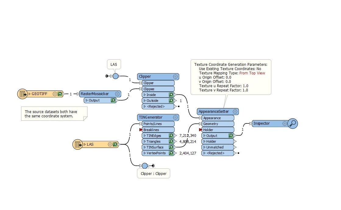
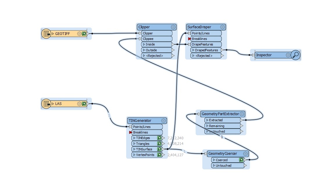
I have tried a couple of methodologies using a point cloud (LAS) to generate a TIN however the quality of the TIN is not good when it comes to trees and the TIN gives steep surfaces below the tree canopy (because the underneath of the tree is not observable). Altering the tolerance can flatten out other trees too much where there is an ability to view through to the canopy floor. It would be more ideal to use already generated meshes and be able to apply the raster image from the geotiff over (Drape) the mesh file. Draping is more realistic and preferable to the textured mesh that comes with the product produced by these programs.

Mesh files are .PLY, .FBX, .DXF, .OBJ, or 3D .PDF

I've looked at

Draping polygonal features on a TIN?

But had problems getting the right parameter into the GeometryPartExtractor.

This was a Geometry XQuery : Geometry IFME polygon.

and

Draping imagery textures on terrain surfaces

and the texture mapping demo


Any advice to improve the TIN or utilise the existing mesh products instead would be appreciated.

@takashi

Here is the other which stops at the GeometryPartExtractor.


Looks like I was trying to complicate things too much.

The FBX can feed directly into the appearance setter without further processing.


But if you have a Mesh with textures can you convert this to a "ortophoto" somehow? Sort of "rasterize the mesh from the top" to be able to export as a Georeferenced Geotiff instead of individual textures on each Mesh? Perhaps something for @daveatsafe


Hi @jamie.milner,

The AppearanceSetter has a setting that lets you easily overlay a georeferenced image onto a surface:

Texture Coordinate Generation Parameters - Texture Mapping Type

Set this to 'Top Down Georeferenced' to have the image applied as a texture exactly where it should.


Hi @jamie.milner,

The AppearanceSetter has a setting that lets you easily overlay a georeferenced image onto a surface:

Texture Coordinate Generation Parameters - Texture Mapping Type

Set this to 'Top Down Georeferenced' to have the image applied as a texture exactly where it should.

In my post below I was looking for the opposite. If you have a Mesh with texture applied - I wan to extract the "georeferenced ortophoto". If that makes sence.


In my post below I was looking for the opposite. If you have a Mesh with texture applied - I wan to extract the "georeferenced ortophoto". If that makes sence.

The AppearanceExtractor will extract the texture images as rasters. If there is a single orthophoto applied as the Mesh Texture, this would work.


The AppearanceExtractor will extract the texture images as rasters. If there is a single orthophoto applied as the Mesh Texture, this would work.

I am thinking about the cases where there is no single ortophoto. But texures on each Mesh. For instance created both from ortophoto on the roof, and from a 3D-scan by car for the buildings on side. I want to sort of create that ortophoto from "any textured Mesh". If that makes sense, however I guess thats more a processing issue and not possible with FME.


I am thinking about the cases where there is no single ortophoto. But texures on each Mesh. For instance created both from ortophoto on the roof, and from a 3D-scan by car for the buildings on side. I want to sort of create that ortophoto from "any textured Mesh". If that makes sense, however I guess thats more a processing issue and not possible with FME.

Have a look at the texture generation parameter created by the AppearanceExtractor if you extract traits as attributes. I think you can use these to project all the appearances onto a flat plane. I did this once, but can't find the workspace.


Looks like I was trying to complicate things too much.

The FBX can feed directly into the appearance setter without further processing.

Nope this just took on the texture in the FBX file. Not the modified geotiff I attempted to drape over the mesh.

Still working on it!


Hi @jamie.milner,

The AppearanceSetter has a setting that lets you easily overlay a georeferenced image onto a surface:

Texture Coordinate Generation Parameters - Texture Mapping Type

Set this to 'Top Down Georeferenced' to have the image applied as a texture exactly where it should.

Thanks Dave,

I could only find From Top view and surface normal options under the Texture Mapping Type. There was no option for georeferencing. Does this mean the parameters in the source files is not correct?


Thanks Dave,

I could only find From Top view and surface normal options under the Texture Mapping Type. There was no option for georeferencing. Does this mean the parameters in the source files is not correct?

The top down option in the AppearanceSetter is fairly new. Please try updating to the latest version of FME 2019, which can be found at safe.com/downloads.


The top down option in the AppearanceSetter is fairly new. Please try updating to the latest version of FME 2019, which can be found at safe.com/downloads.


Thanks Dave. That got it. The TIN Generator from Geotiff or LAS files unfortunately creates very angular features. I'd ideally like to use a fbx file generated from a mapping program as the source for the surface as it has a surface that accounts for some canopy like trees. That is the surface is far more refined. However when I use the fbx file stripped of the textures into the appearance setter I get some weird outcomes. or I get just the surface and the raster won't imprint on it through the appearance setter. Any ideas?


Reply