Question

Does the hidden attributes really have to pass through the pointonareaoverlayer?!

  • 13 February 2013
  • 6 replies
  • 6 views

Hi!


Yesterday, a college of mine and I, struggled with a funky workspace.


It is wery simple:


An area in TAB-format. A list of XY coordinates. A 2Dpointcreator and a pointonareaoverlayer. The points inside the area is written to a TAB-file destination.


Somehow, the points inherits the hidden attributes from the area(eg mapinfo_type=polygon) and will be considered to be corrupt geometry by the writer! The fme_type value of the features is naturally "point".


Does the hidden attributes really have to pass through the pointonareaoverlayer?! 


I didnt find it intuitive that is is...


What do you think?


Greetings from Go:teborg!


Håkan
Hi,


If these attributes are not desired, you can remove them before writting (attributeremover or attributkeeper).


Hope this helps.
I have had similar problems with mapinfo attributes causing unexpected behaviour later in the workspace. The easiest solution is to remove these as a first step.
If possible I prefer to use an AttributeKEEPER just before writing, instead of an AttributeRemover. This is to prevent any "junk" attributes to be written. Using Dynamic Reader and Dynamic Writer makes it more interesting...
Yes, you are all right here. 


Yesterday we solved this problem the same way you suggest.


Does thoose junk attributes ever help?!


How about not bringing them on at all, unless you tell them to, by exposing them in the reader properties?


It all seems to be a work around for something that doesn't have to be a problem from the very beginning!
Hi Håkan,


I agree it's not ideal, but some users do actually want to merge format attributes (though not geometry usually). I'll file a request with our developers to see if there is anything they can do.


Incidentally, I usually use the AttributeExpressionRemover (now BulkAttributeRemover in FME2013) to remove anything starting (in this case) mapinfo_*


Regards


Mark


Mark Ireland


Product Evangelist, Safe Software Inc
Hi Mark!


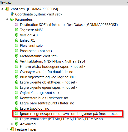
That reminds me about a setting we have on all our formats (Quadri, QMS, SOSI) in our own plugin (GDMMapper). On each writer we have the possibility to add a "Ignore attributes with names that start with:" So below all features with attributes that starts with "fme" and "autocad" will automatically be removed before writing to the SOSI-format. Might be possible to implement. Perhaps you can easily implement something like this on "all" formats?


Below is a copy of the settings for a writer:

Reply