Question

Derive largest inscribed convex polygon

  • February 14, 2017
  • 4 replies
  • 47 views

olivier
Contributor
Forum|alt.badge.img+7

Hello!

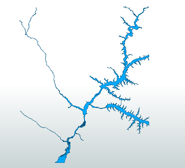
I have polygon geometry representing water areas obtained from satellite imagery. They are sometimes very large and include multiple rivers inside the same polygon. I would need to decompose/split those huge polygons into smaller ones in order to have one distinct polygon for each river. This is just one polygon:

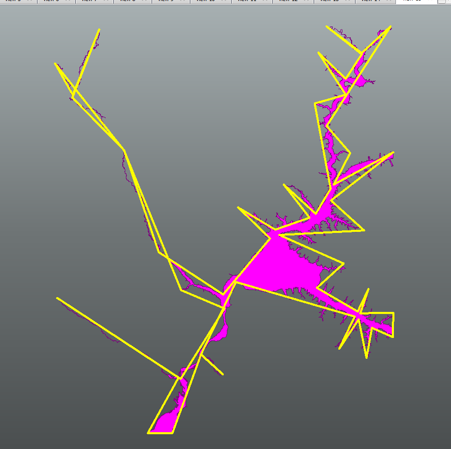
I would need to identify the main tributaries and seperate them into distinct polygons. Tributaries would be cut from the main stem more or less according to the following dividing line:

I am still not sure how this could be automated given the very irregular nature of the polygon. I would also need to decide what a relevant tributary is (width of the junction and/or area upstream,...).

I have made some attempts at obtaining a sort of skeleton using the CenterLineReplacer transformer but it ends up with a crash even after generalization. I am also looking at whether it would be possible to have FME calculate the biggest inscribed convex polygons and use the result of these in order to derive a sort of dividing line between the major waterways. I did not find a transformer for that but if you think you see an approach for solving the problem, I would be very glad if you could share it with me.

I have attached the original polygon () in case you want to play around with it.

Thanks!

Olivier

4 replies

itay
Supporter
Forum|alt.badge.img+17
  • Supporter
  • February 14, 2017

I personally think you are better off drawing the division lines manually and using them in the clipping. Sometimes it's the most effiecient way....


olivier
Contributor
Forum|alt.badge.img+7
  • Author
  • Contributor
  • February 15, 2017

Thank you @itay!

This is indeed something I am considering doing. But I first wanted to rule out all efficient automated options because we may need to perform these tasks for very large areas around the world. These shapes are generated from a machine learning methodology.


itay
Supporter
Forum|alt.badge.img+17
  • Supporter
  • February 15, 2017
olivier wrote:

Thank you @itay!

This is indeed something I am considering doing. But I first wanted to rule out all efficient automated options because we may need to perform these tasks for very large areas around the world. These shapes are generated from a machine learning methodology.

So teach it to draw it right :)


itay
Supporter
Forum|alt.badge.img+17
  • Supporter
  • February 15, 2017
olivier wrote:

Thank you @itay!

This is indeed something I am considering doing. But I first wanted to rule out all efficient automated options because we may need to perform these tasks for very large areas around the world. These shapes are generated from a machine learning methodology.

Hi @olivier,


even if there is an automated option probably a manual step to verify the automated step will be necessary. Tha is my experience with this kind of solutions.


Results from playing with the generalizer


Cookie policy

We use cookies to enhance and personalize your experience. If you accept you agree to our full cookie policy. Learn more about our cookies.

 
Cookie settings