Solved

Convert json-file to ESRI line feature class


ireen
Contributor
Forum|alt.badge.img+5
  • Contributor

I have a json-file (see attachment) that contains the coördinates of a circular route. It looks like this:

{

 "segments": [{

  "geometry": {

   "type": "LineString",

   "coordinates": [

    [50.814103, 4.521174],

    [50.81309, 4.521811],

    [50.80626, 4.536902],

    [50.80482, 4.538866],

    [50.80573, 4.541452],

    [50.80621, 4.543173],

    [50.80705, 4.545501],

    [50.80755, 4.546541],

    [50.80777, 4.546841],

    [50.80919, 4.547739],

    [50.8096, 4.548199],

    [50.81052, 4.550243],

    [50.810663, 4.551096]

   ]

  },

  {

  "geometry": {

   "type": "LineString",

   "coordinates": [

    [50.810663, 4.551096],

    [50.81065, 4.555264],

    [50.81071, 4.555622]

   ]

  },

...


I want to convert it to an ESRI line feature class, but I'm stuck. The geojsonreader gives no error, but also no result as reader. 


Json-fragmenter gives me the list of vertices in an attribute, but I can't fix it to convert these points to vertices/line.

imageSomeone who can help me out?

Best answer by nielsgerrits

ireen wrote:

This is what I was looking for. Thanks a lot!!

As always the are different approaches to solve these things. I attached a workspace which solves the segments in a more elegant way. The geometry in the nodes and unpaved segments is not in a default format, so this still need to be done manually.

2023-03-28_10h17_24

View original
Did this help you find an answer to your question?

10 replies

nielsgerrits
VIP
Forum|alt.badge.img+54

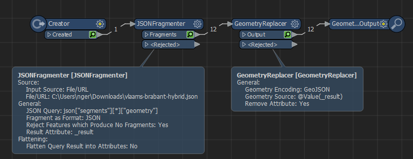
Use a JSONFragmenter with the query  

json["segments"][*]["geometry"]

to get the individual geometry per segment, then use a GeometryReplacer set to GeoJSON to get the geometry from it.

2023-03-27_13h33_12


ireen
Contributor
Forum|alt.badge.img+5
  • Author
  • Contributor
  • March 27, 2023
nielsgerrits wrote:

Use a JSONFragmenter with the query  

json["segments"][*]["geometry"]

to get the individual geometry per segment, then use a GeometryReplacer set to GeoJSON to get the geometry from it.

2023-03-27_13h33_12

This is what I was looking for. Thanks a lot!!


nielsgerrits
VIP
Forum|alt.badge.img+54
ireen wrote:

This is what I was looking for. Thanks a lot!!

cheers:)


ireen
Contributor
Forum|alt.badge.img+5
  • Author
  • Contributor
  • March 28, 2023
ireen wrote:

This is what I was looking for. Thanks a lot!!

Niels,

To extract the nodes from the json-file, I did the following:

imageThis works fine, but I assume there is an easier way to get the points (including their attributes)?

ireen
Contributor
Forum|alt.badge.img+5
  • Author
  • Contributor
  • March 28, 2023
nielsgerrits wrote:

Use a JSONFragmenter with the query  

json["segments"][*]["geometry"]

to get the individual geometry per segment, then use a GeometryReplacer set to GeoJSON to get the geometry from it.

2023-03-27_13h33_12

Looking at the result, I see that the spatial location is not correct. The GeometryReplacer translates the [Lat,Long] to [X,Y] instead of [Y,X]. The GeoJSON Geometry encoding has no possibility to change the axis order. Anybody an idea to solve this?


nielsgerrits
VIP
Forum|alt.badge.img+54
ireen wrote:

Looking at the result, I see that the spatial location is not correct. The GeometryReplacer translates the [Lat,Long] to [X,Y] instead of [Y,X]. The GeoJSON Geometry encoding has no possibility to change the axis order. Anybody an idea to solve this?

Yes I just found the same :) The CoordinateSwapper can fix this.


nielsgerrits
VIP
Forum|alt.badge.img+54
  • Best Answer
  • March 28, 2023
ireen wrote:

This is what I was looking for. Thanks a lot!!

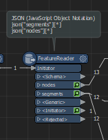
As always the are different approaches to solve these things. I attached a workspace which solves the segments in a more elegant way. The geometry in the nodes and unpaved segments is not in a default format, so this still need to be done manually.

2023-03-28_10h17_24


ireen
Contributor
Forum|alt.badge.img+5
  • Author
  • Contributor
  • March 28, 2023
ireen wrote:

This is what I was looking for. Thanks a lot!!

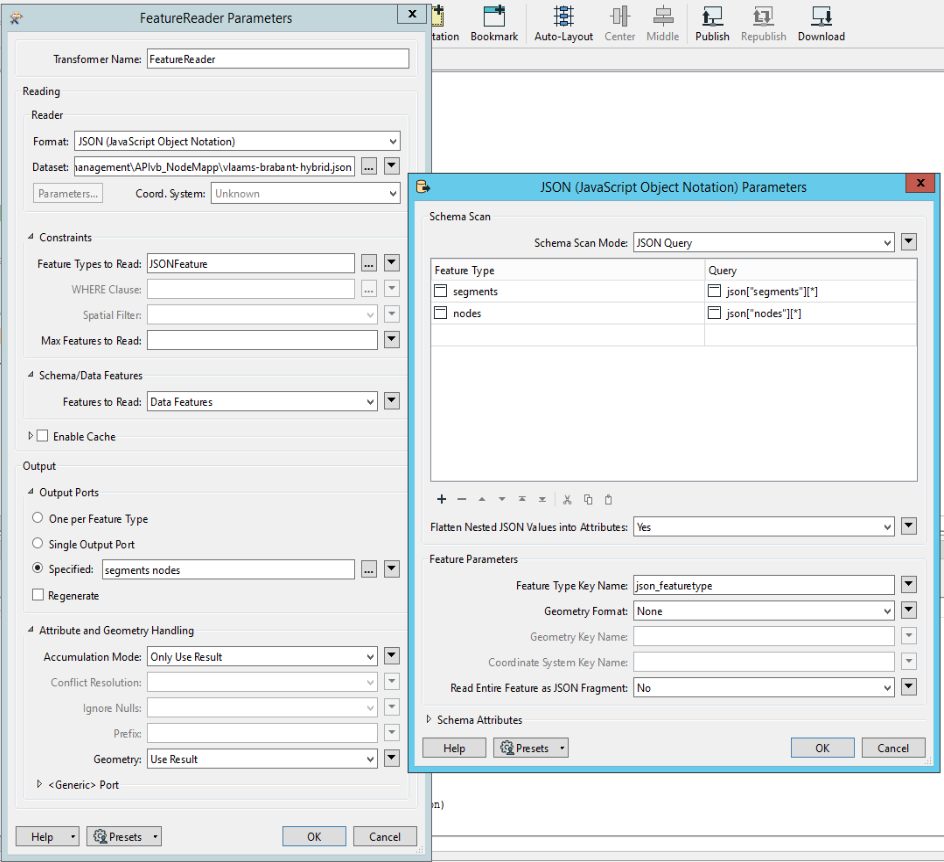
Where exactly in the FeatureReader do you define the queries for the output ports?

imageI did this, but no succes:

image


nielsgerrits
VIP
Forum|alt.badge.img+54
ireen wrote:

This is what I was looking for. Thanks a lot!!

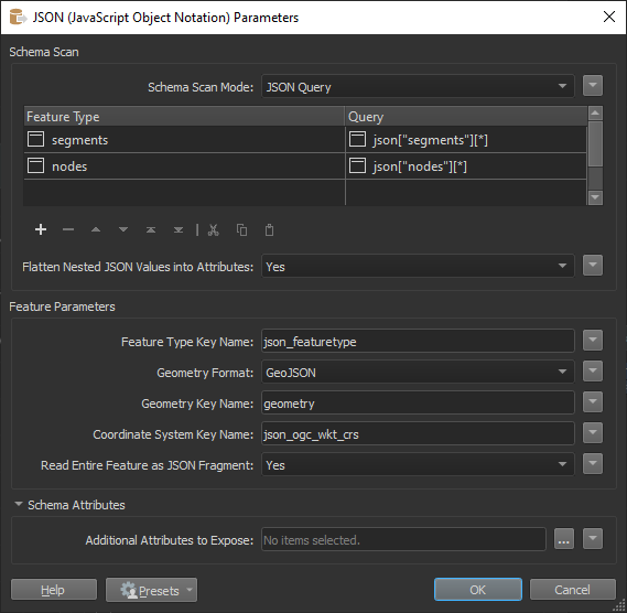
This is correct, then under Parameters set Geometry Format to GeoJSON and set Geometry Key Name = "geometry".

2023-03-28_11h05_26


ireen
Contributor
Forum|alt.badge.img+5
  • Author
  • Contributor
  • March 28, 2023
ireen wrote:

This is what I was looking for. Thanks a lot!!

Thank s a lot, Niels. Works fine.


Reply


Cookie policy

We use cookies to enhance and personalize your experience. If you accept you agree to our full cookie policy. Learn more about our cookies.

 
Cookie settings