Hi. I'm trying to get a single output from these two sources:
County Assessor Parcel Boundaries
Surveyed Parcel Boundaries
The goal is that, if the parcel is in the Surveyed Parcel Boundaries layer, we use its shape. If not, we keep the County Assessor layer shape. Only some of our records are in both sources. Some are in one and not the other.
Which transformer would be best for this scenario, and how would I go about setting it up? Thanks!
Best answer by zzordo
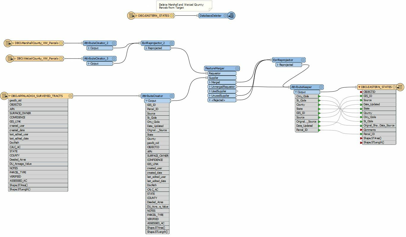
I managed to get something to work using the FeatureMerger Transformer instead. It works as follows:
First Delete Marshall and Wetzel County Parcels from Target Dataset
AttributeCreator and AttributeKeeper Transformers to Adjust and Narrow Down Columns (for example, reformat a Wetzel County Parcel APN to be something like WV-103-1-1-1, but Marshall County to be like WV-51-1-1-1)
Use EsriReprojector - Sources were USA Contiguous Alberts Equal Area Conic or NAD 1983 UTM Zone 17N US FT, Destination is GCS North American 1983
FeatureMerger Transformer with a Join On matching unique parcel identifiers (GIS_ID in Requestor, GIS_LINK in Supplier)
UnmergedRequestors were untouched by FeatureMerger, and skipped EsriReprojector at the next step since they had already been reprojected
Merged, UnusedSupplier, and <Rejected> all took attribution and/or new shapes from the surveyed tracts, and went through EsriReprojector (since they hadn't been reprojected yet)
This post is closed to further activity.
It may be an old question, an answered question, an implemented idea, or a notification-only post.
Please check post dates before relying on any information in a question or answer.
For follow-up or related questions, please post a new question or idea.
If there is a genuine update to be made, please contact us and request that the post is reopened.
Is there a common id between the datasets? If so I would try the ChangeDetector.
If not, then I would try something along the lines of using the County Assessor as the filters in a spatial filter (intersects) and keep only the Failed parcels from the surveyed along with the complete assessor dataset.
I managed to get something to work using the FeatureMerger Transformer instead. It works as follows:
First Delete Marshall and Wetzel County Parcels from Target Dataset
AttributeCreator and AttributeKeeper Transformers to Adjust and Narrow Down Columns (for example, reformat a Wetzel County Parcel APN to be something like WV-103-1-1-1, but Marshall County to be like WV-51-1-1-1)
Use EsriReprojector - Sources were USA Contiguous Alberts Equal Area Conic or NAD 1983 UTM Zone 17N US FT, Destination is GCS North American 1983
FeatureMerger Transformer with a Join On matching unique parcel identifiers (GIS_ID in Requestor, GIS_LINK in Supplier)
UnmergedRequestors were untouched by FeatureMerger, and skipped EsriReprojector at the next step since they had already been reprojected
Merged, UnusedSupplier, and <Rejected> all took attribution and/or new shapes from the surveyed tracts, and went through EsriReprojector (since they hadn't been reprojected yet)

")