Question

Aggregator issues with ArcMap but works with FME

  • June 12, 2020
  • 1 reply
  • 15 views

Hi all,


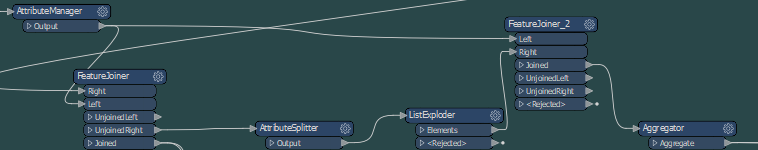
I have been trying to put together some GIS data we have that was in a list format. When i use FME and check with the inspector this looks fine, data is what i am after. The same when i produce this in QGIS, looks fine.

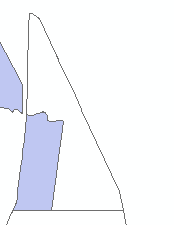
When using arcmap, i seem to see some of the shapes are not getting the same symbology and just displays the outline of the shape. Does anyone know why this might be the case and is there a solution to this issue?


This post is closed to further activity.
It may be an old question, an answered question, an implemented idea, or a notification-only post.
Please check post dates before relying on any information in a question or answer.
For follow-up or related questions, please post a new question or idea.
If there is a genuine update to be made, please contact us and request that the post is reopened.

1 reply

fmelizard
Safer
Forum|alt.badge.img+21
  • Safer
  • June 15, 2020

Hi @gisrewards Check to see if the aggregate contains identical overlapping shapes. ArcMap might be reading it as a donut with identical shells.